File:River Wye in High Wycombe - geograph.org.uk - 925295.jpg
Jump to navigation
Jump to search
No higher resolution available.
River_Wye_in_High_Wycombe_-_geograph.org.uk_-_925295.jpg (640 × 480 pixels, file size: 81 KB, MIME type: image/jpeg)
Captions
Captions
Add a one-line explanation of what this file represents
Summary
[edit]
| Description |
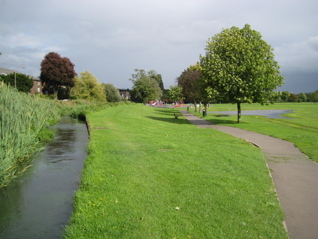
English: River Wye in High Wycombe This is an example of a river not flowing along the lowest line through its valley. The ground drops noticeably from left to right from the river into The Rye, and a small pond of flood water has accumulated to the right of the tree after recent heavy rain. In this case the river bank has probably been built up by man to provide a head of water to power a mill further downstream. |
| Date | |
| Source | From geograph.org.uk |
| Author | Nigel Cox |
| Attribution (required by the license) | Nigel Cox / River Wye in High Wycombe / |
| Camera location | | View this and other nearby images on: OpenStreetMap |
|---|
_heading:112.00&language=en)
| Object location | | View this and other nearby images on: OpenStreetMap |
|---|
_heading:112.00&language=en)
Licensing
[edit]

|
This image was taken from the Geograph project collection. See this photograph's page on the Geograph website for the photographer's contact details. The copyright on this image is owned by Nigel Cox and is licensed for reuse under the Creative Commons Attribution-ShareAlike 2.0 license.
|
This file is licensed under the Creative Commons Attribution-Share Alike 2.0 Generic license.
Attribution: Nigel Cox
- You are free:
- to share – to copy, distribute and transmit the work
- to remix – to adapt the work
- Under the following conditions:
- attribution – You must give appropriate credit, provide a link to the license, and indicate if changes were made. You may do so in any reasonable manner, but not in any way that suggests the licensor endorses you or your use.
- share alike – If you remix, transform, or build upon the material, you must distribute your contributions under the same or compatible license as the original.
File history
Click on a date/time to view the file as it appeared at that time.
| Date/Time | Thumbnail | Dimensions | User | Comment | |
|---|---|---|---|---|---|
| current | 03:49, 22 February 2011 | | 640 × 480 (81 KB) | GeographBot (talk | contribs) | == {{int:filedesc}} == {{Information |description={{en|1=River Wye in High Wycombe This is an example of a river not flowing along the lowest line through its valley. The ground drops noticeably from left to right from the river into The Rye, and a small |
You cannot overwrite this file.
File usage on Commons
There are no pages that use this file.