File:River Parret at Oath - geograph.org.uk - 1136606.jpg
Jump to navigation
Jump to search
No higher resolution available.
River_Parret_at_Oath_-_geograph.org.uk_-_1136606.jpg (640 × 428 pixels, file size: 111 KB, MIME type: image/jpeg)
Captions
Captions
Add a one-line explanation of what this file represents
Summary
[edit]| Description |
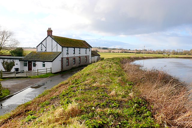
English: River Parret at Oath The river has high embankments so that it can carry large volumes of water in spate with out flooding adjacent land. As can be seen the river is 4-5m above the level of the road and the ground floor of the house. The house is on the road from Oath to Stathe at the eastern end of West Sedgemoor. There is a pump house further along the road where water is pumped up from the moor into the river. When the river reaches the top of its banks, as it nearly is here, the moor is allowed to flood to protect property further downstream. |
| Date | |
| Source | From geograph.org.uk |
| Author | Nigel Mykura |
| Camera location | | View this and other nearby images on: OpenStreetMap |
|---|
| Object location | | View this and other nearby images on: OpenStreetMap |
|---|
Licensing
[edit]
|
This image was taken from the Geograph project collection. See this photograph's page on the Geograph website for the photographer's contact details. The copyright on this image is owned by Nigel Mykura and is licensed for reuse under the Creative Commons Attribution-ShareAlike 2.0 license.
|
This file is licensed under the Creative Commons Attribution-Share Alike 2.0 Generic license.
Attribution: Nigel Mykura
- You are free:
- to share – to copy, distribute and transmit the work
- to remix – to adapt the work
- Under the following conditions:
- attribution – You must give appropriate credit, provide a link to the license, and indicate if changes were made. You may do so in any reasonable manner, but not in any way that suggests the licensor endorses you or your use.
- share alike – If you remix, transform, or build upon the material, you must distribute your contributions under the same or compatible license as the original.

_heading:270.00&language=en)
_heading:270.00&language=en)
File history
Click on a date/time to view the file as it appeared at that time.
| Date/Time | Thumbnail | Dimensions | User | Comment | |
|---|---|---|---|---|---|
| current | 04:36, 25 February 2011 | | 640 × 428 (111 KB) | GeographBot (talk | contribs) | == {{int:filedesc}} == {{Information |description={{en|1=River Parret at Oath The river has high embankments so that it can carry large volumes of water in spate with out flooding adjacent land. As can be seen the river is 4-5m above the level of the road |
You cannot overwrite this file.
File usage on Commons
There are no pages that use this file.