File:River Don aqueduct - geograph.org.uk - 2910.jpg
Jump to navigation
Jump to search
No higher resolution available.
River_Don_aqueduct_-_geograph.org.uk_-_2910.jpg (640 × 480 pixels, file size: 23 KB, MIME type: image/jpeg)
Captions
Captions
Add a one-line explanation of what this file represents
Summary
[edit]
| Description |
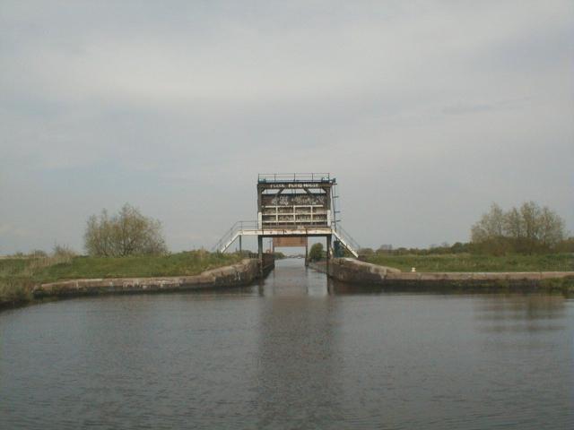
English: River Don aqueduct. The structure ahead is the aqueduct taking the New Junction Canal over the River Don. In times of flood the level of the River can become higher than that of the canal and flow over the top of the aqueduct. In order to prevent the canal then flooding the low lying land each end of the aqueduct is fitted with a guillotine gate which can be lower to form part of the flood defences to keep the river within its banks. |
| Date | |
| Source | From geograph.org.uk |
| Author | David Stowell |
| Attribution (required by the license) | David Stowell / River Don aqueduct / |
| Object location | | View this and other nearby images on: OpenStreetMap |
|---|
_&language=en)
Licensing
[edit]

|
This image was taken from the Geograph project collection. See this photograph's page on the Geograph website for the photographer's contact details. The copyright on this image is owned by David Stowell and is licensed for reuse under the Creative Commons Attribution-ShareAlike 2.0 license.
|
This file is licensed under the Creative Commons Attribution-Share Alike 2.0 Generic license.
Attribution: David Stowell
- You are free:
- to share – to copy, distribute and transmit the work
- to remix – to adapt the work
- Under the following conditions:
- attribution – You must give appropriate credit, provide a link to the license, and indicate if changes were made. You may do so in any reasonable manner, but not in any way that suggests the licensor endorses you or your use.
- share alike – If you remix, transform, or build upon the material, you must distribute your contributions under the same or compatible license as the original.
File history
Click on a date/time to view the file as it appeared at that time.
| Date/Time | Thumbnail | Dimensions | User | Comment | |
|---|---|---|---|---|---|
| current | 03:16, 30 January 2010 | | 640 × 480 (23 KB) | GeographBot (talk | contribs) | == {{int:filedesc}} == {{Information |description={{en|1=River Don aqueduct. The structure ahead is the aqueduct taking the New Junction Canal over the River Don. In times of flood the level of the River can become higher than that of the canal and flow |
You cannot overwrite this file.
File usage on Commons
There are no pages that use this file.