File:River Dene in Charlecote Park - geograph.org.uk - 1567599.jpg
Jump to navigation
Jump to search
No higher resolution available.
River_Dene_in_Charlecote_Park_-_geograph.org.uk_-_1567599.jpg (640 × 480 pixels, file size: 132 KB, MIME type: image/jpeg)
Captions
Captions
Add a one-line explanation of what this file represents
Summary
[edit]
| Description |
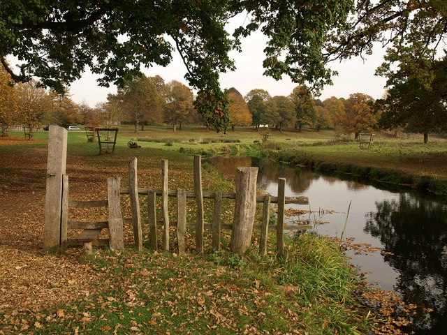
English: River Dene in Charlecote Park Looking upstream. The section of fence in the foreground exemplifies the style used around the park. The variable height of the uprights confuses the deer and prevents them from jumping it, apparently. The construction of pale fences like this is explained at http://handbooks.btcv.org.uk/handbooks/content/section/3305 , with a reference to that at Charlecote being at least 400 years old, although I imagine it has been renewed a few times. |
| Date | |
| Source | From geograph.org.uk |
| Author | Derek Harper |
| Attribution (required by the license) | Derek Harper / River Dene in Charlecote Park / |
| Camera location | | View this and other nearby images on: OpenStreetMap |
|---|
_heading:67.00&language=en)
| Object location | | View this and other nearby images on: OpenStreetMap |
|---|
_heading:67.00&language=en)
Licensing
[edit]

|
This image was taken from the Geograph project collection. See this photograph's page on the Geograph website for the photographer's contact details. The copyright on this image is owned by Derek Harper and is licensed for reuse under the Creative Commons Attribution-ShareAlike 2.0 license.
|
This file is licensed under the Creative Commons Attribution-Share Alike 2.0 Generic license.
Attribution: Derek Harper
- You are free:
- to share – to copy, distribute and transmit the work
- to remix – to adapt the work
- Under the following conditions:
- attribution – You must give appropriate credit, provide a link to the license, and indicate if changes were made. You may do so in any reasonable manner, but not in any way that suggests the licensor endorses you or your use.
- share alike – If you remix, transform, or build upon the material, you must distribute your contributions under the same or compatible license as the original.
File history
Click on a date/time to view the file as it appeared at that time.
| Date/Time | Thumbnail | Dimensions | User | Comment | |
|---|---|---|---|---|---|
| current | 17:47, 3 March 2011 | | 640 × 480 (132 KB) | GeographBot (talk | contribs) | == {{int:filedesc}} == {{Information |description={{en|1=River Dene in Charlecote Park Looking upstream. The section of fence in the foreground exemplifies the style used around the park. The variable height of the uprights confuses the deer and prevents |
You cannot overwrite this file.
File usage on Commons
There are no pages that use this file.