File:Rim Fire 20130817-FS-UNK-0080 (9773107002).jpg
Jump to navigation
Jump to search

Size of this preview: 800 × 600 pixels. Other resolutions: 320 × 240 pixels | 640 × 480 pixels | 1,024 × 768 pixels | 1,280 × 960 pixels | 2,560 × 1,920 pixels | 3,264 × 2,448 pixels.
Original file (3,264 × 2,448 pixels, file size: 1.69 MB, MIME type: image/jpeg)
Captions
Captions
Add a one-line explanation of what this file represents
Summary
[edit].jpg&action=edit§ion=1)
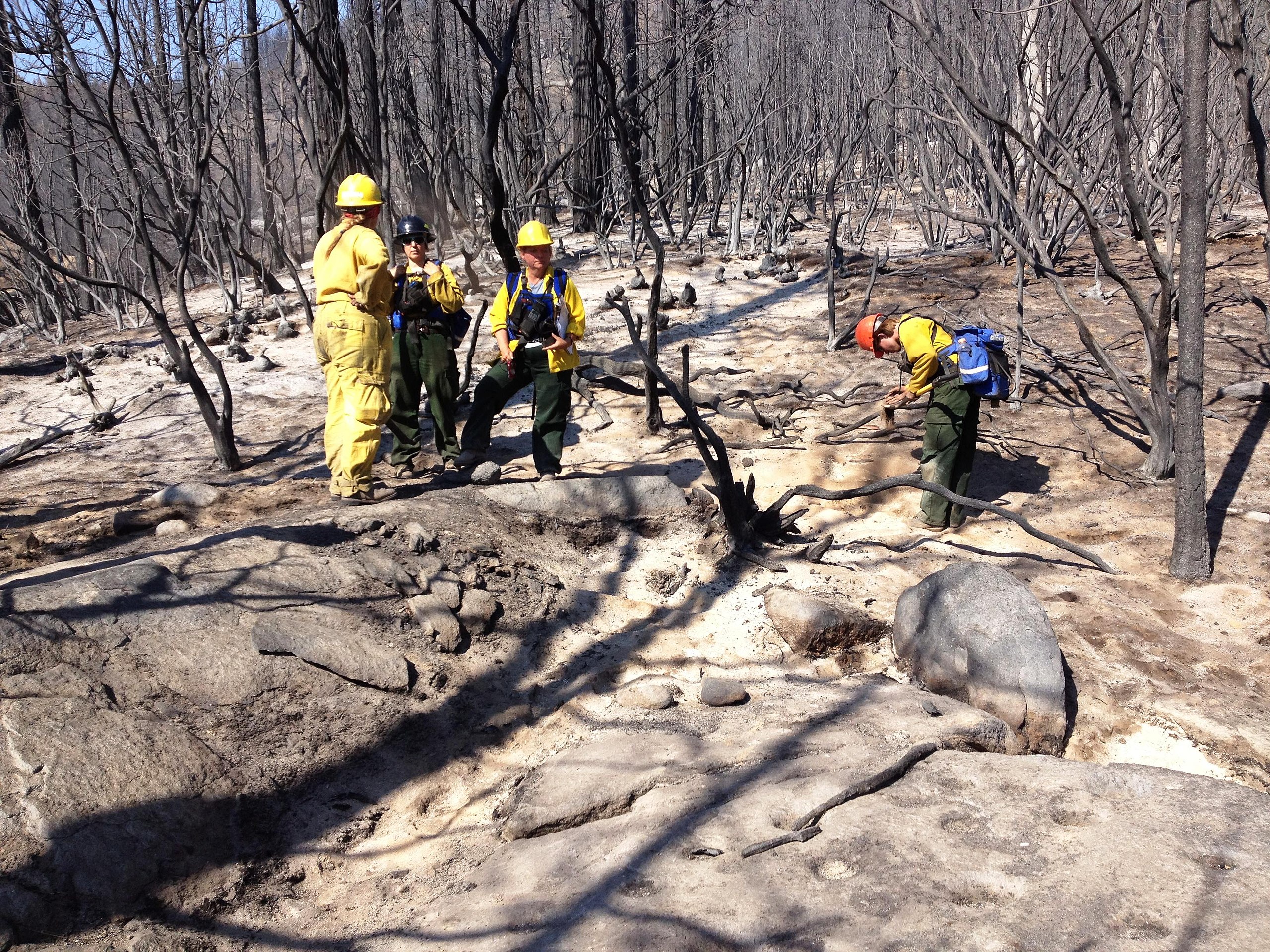
| Description | Burned Area Emergency Response (BAER) archeologists and soil scientists assess burned area at Rim Fire. . BAER teams start work even before the fire is completely extinguished at the Rim Fire. BAER is a rapid assessment of burned watersheds by a BAER team to identify imminent post-wildfire threats to human life and safety property and critical natural or cultural resources on National Forest System lands and take immediate actions to implement emergency stabilization measures before the first major storms. Fires result in loss of vegetation exposure of soil to erosion and increased water runoff that may lead to flooding increased sediment debris flows and damage to critical natural and cultural resources. BAER team members implement seeding and mulching installation to prevent erosion, erect temporary water run-off control structures that will protect recovering areas, and installation of warning signs, replace safety related facilities, remove safety hazards, prevent permanent loss of habitat for threatened and endangered species, and prevent the spread of noxious weeds and protect critical cultural resources. The Rim Fire in the Stanislaus National Forest near in California began on Aug. 17, 2013 and is under investigation. The fire has consumed approximately 256,169 acres and is 84% contained. U.S. Forest Service photo by Dorit Buckley. |
| Date | |
| Source | 20130817-FS-UNK-0080 |
| Author | U.S. Department of Agriculture |
Licensing
[edit].jpg&action=edit§ion=2)
This file is licensed under the Creative Commons Attribution 2.0 Generic license.
- You are free:
- to share – to copy, distribute and transmit the work
- to remix – to adapt the work
- Under the following conditions:
- attribution – You must give appropriate credit, provide a link to the license, and indicate if changes were made. You may do so in any reasonable manner, but not in any way that suggests the licensor endorses you or your use.
| This image was originally posted to Flickr by USDAgov at https://flickr.com/photos/41284017@N08/9773107002. It was reviewed on 28 June 2016 by FlickreviewR and was confirmed to be licensed under the terms of the cc-by-2.0. |
File history
Click on a date/time to view the file as it appeared at that time.
| Date/Time | Thumbnail | Dimensions | User | Comment | |
|---|---|---|---|---|---|
| current | 04:45, 28 June 2016 | | 3,264 × 2,448 (1.69 MB) | XR728 (talk | contribs) | Transferred from Flickr via Flickr2Commons |
You cannot overwrite this file.
File usage on Commons
There are no pages that use this file.
.jpg&oldid=482372285)