File:Ridge to Punta Caldera.jpg
Jump to navigation
Jump to search

Size of this preview: 800 × 253 pixels. Other resolutions: 320 × 101 pixels | 640 × 202 pixels | 1,024 × 323 pixels | 1,280 × 404 pixels | 2,560 × 808 pixels | 7,194 × 2,271 pixels.
Original file (7,194 × 2,271 pixels, file size: 8.78 MB, MIME type: image/jpeg)
Captions
Captions
Add a one-line explanation of what this file represents
Summary
[edit]| Description |
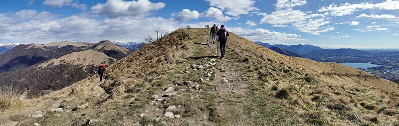
Italiano: La breve cresta che dalla Bocchetta del Bolettone sale sulla panoramica altura di Punta Caldera, a cavallo del confine tra i comuni di Faggeto Lario e di Albavilla. Sulla sinistra si vede il Sentiero delle Colme, che dalla Bocchetta del Bolettone procede in direzione della Bocchetta di Lemna, aggirando sul fianco nord-ovest la cima della Punta Caldera. |
||
| Date | |||
| Source |
Own work
|
||
| Author | Kaitu |

| Camera location | | View this and other nearby images on: OpenStreetMap |
|---|
This image was created with Hugin.
Licensing
[edit]
I, the copyright holder of this work, hereby publish it under the following license:
| This file is made available under the Creative Commons CC0 1.0 Universal Public Domain Dedication. | |
| The person who associated a work with this deed has dedicated the work to the public domain by waiving all of their rights to the work worldwide under copyright law, including all related and neighboring rights, to the extent allowed by law. You can copy, modify, distribute and perform the work, even for commercial purposes, all without asking permission.
|
| Annotations | This image is annotated: View the annotations at Commons |
File history
Click on a date/time to view the file as it appeared at that time.
| Date/Time | Thumbnail | Dimensions | User | Comment | |
|---|---|---|---|---|---|
| current | 14:19, 25 March 2024 | 7,194 × 2,271 (8.78 MB) | Kaitu (talk | contribs) | Uploaded own work with UploadWizard |
You cannot overwrite this file.
File usage on Commons
The following page uses this file:
File usage on other wikis
The following other wikis use this file:
- Usage on ceb.wikipedia.org
- Usage on www.wikidata.org