File:Rhus copallinum range map 3.png
Jump to navigation
Jump to search

Size of this preview: 600 × 600 pixels. Other resolutions: 240 × 240 pixels | 480 × 480 pixels | 768 × 768 pixels | 1,024 × 1,024 pixels | 2,048 × 2,048 pixels | 4,860 × 4,860 pixels.
Original file (4,860 × 4,860 pixels, file size: 363 KB, MIME type: image/png)
Captions
Captions
Add a one-line explanation of what this file represents
Summary
[edit]
| Description |
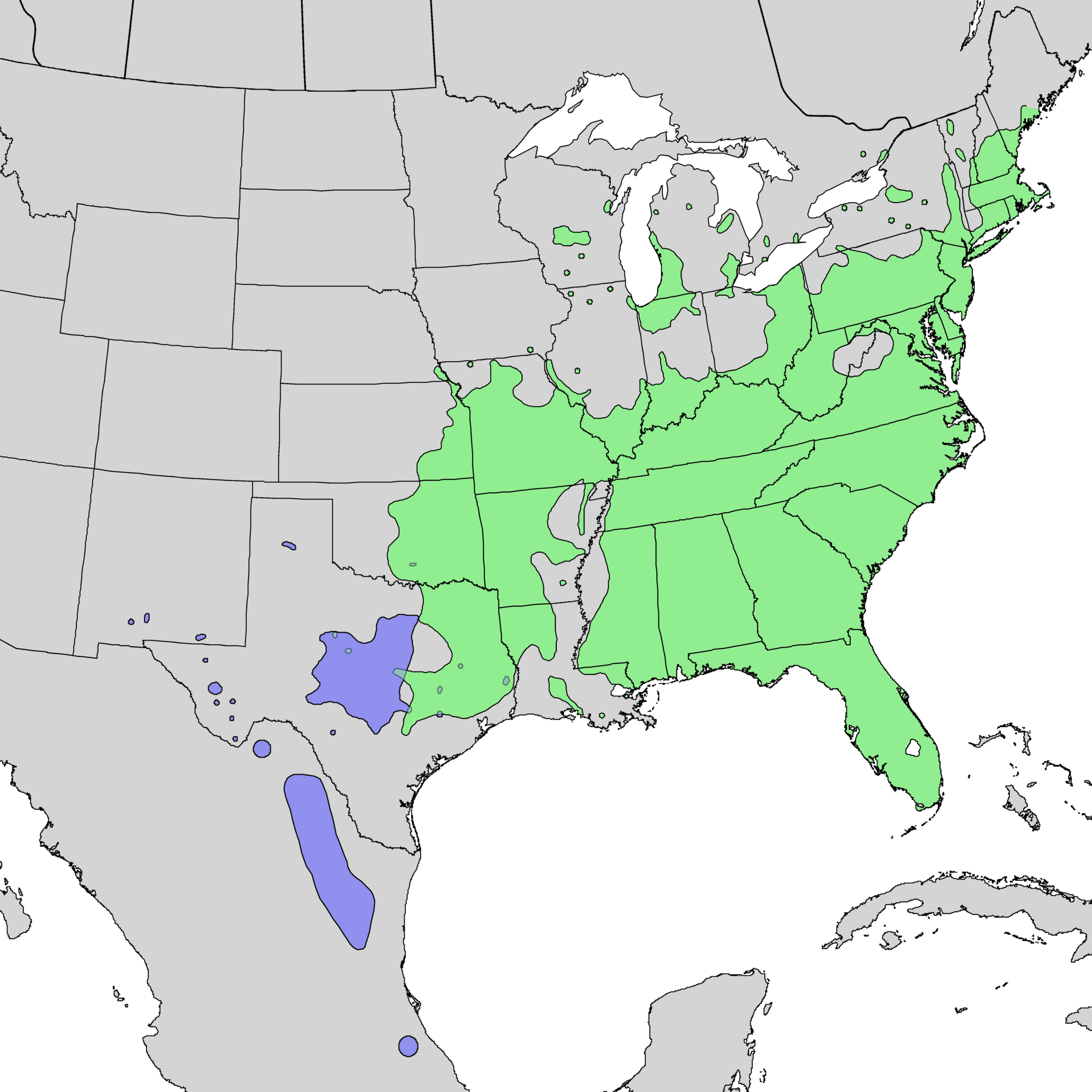
English: Range map of Rhus copallinum var. copallinum (green) and var. lanceolata (blue) |
| Date | 1976, 1977 & 1999 |
| Source | USGS Geosciences and Environmental Change Science Center: Digital Representations of Tree Species Range Maps from: Elbert L. Little, Jr. (1976), Atlas of United States trees, Vol. 3, minor Western hardwoods: U.S. Department of Agriculture Miscellaneous Publication 1314, 13 p., 290 maps and Elbert L. Little, Jr. (1977), Atlas of United States trees, Vol. 4, minor Eastern hardwoods: U.S. Department of Agriculture Miscellaneous Publication 1342, 17 p., 230 maps. |
| Author | Elbert L. Little, Jr., of the U.S. Department of Agriculture, Forest Service / U.S. Geological Survey |
Licensing
[edit]
This image is in the public domain in the United States because it only contains materials that originally came from the United States Geological Survey, an agency of the United States Department of the Interior. For more information, see the official USGS copyright policy.
|
Original upload log
[edit]
Transferred from en.wikipedia to Commons by Pinethicket using CommonsHelper.
The original description page was here. All following user names refer to en.wikipedia.
- 2010-05-16 05:11 Masebrock 626×545× (114346 bytes) {{Information |Description=Range map of Rhus copallina |Source=Digital representation of "Atlas of United States Trees" by Elbert L. Little, Jr. [http://esp.cr.usgs.gov/data/atlas/little/] |Date=1999 |Author=U.S. Geological Survey |Permission={{PD-USGov-
File history
Click on a date/time to view the file as it appeared at that time.
| Date/Time | Thumbnail | Dimensions | User | Comment | |
|---|---|---|---|---|---|
| current | 21:31, 20 December 2013 | | 4,860 × 4,860 (363 KB) | Nonenmac (talk | contribs) | higher resolution, no striping problem, white water bodies, province borders, both subtaxa, color-coded |
| 20:44, 22 October 2012 |  | 626 × 545 (112 KB) | File Upload Bot (Magnus Manske) (talk | contribs) | Transfered from en.wikipedia by User:Pinethicket using CommonsHelper |
You cannot overwrite this file.
File usage on Commons
The following 4 pages use this file:
File usage on other wikis
The following other wikis use this file:
- Usage on ceb.wikipedia.org
- Usage on en.wikipedia.org
- Usage on es.wikipedia.org
- Usage on sv.wikipedia.org
- Usage on www.wikidata.org
- Usage on zh.wikipedia.org