File:Remains of Woodhay Railway Station (2) (geograph 2366261).jpg
Jump to navigation
Jump to search
Size of this preview: 800 × 533 pixels. Other resolutions: 320 × 213 pixels | 640 × 427 pixels | 1,024 × 683 pixels | 1,280 × 853 pixels | 1,536 × 1,024 pixels.
Original file (1,536 × 1,024 pixels, file size: 1.21 MB, MIME type: image/jpeg)
Captions
Captions
Add a one-line explanation of what this file represents
Summary
[edit]_(geograph_2366261).jpg&action=edit§ion=1)
| Description |
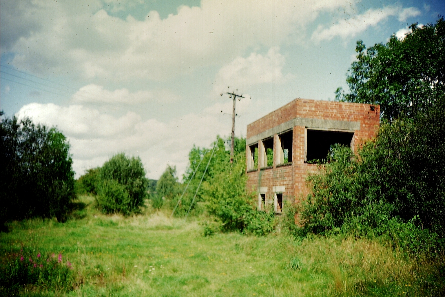
English: Remains of Woodhay Railway Station (2) Taken in August 1992, this photo shows the track and signalbox at Woodhay Station which was on the railway between Newbury and Southampton. The signalbox was opened in October, 1942, replacing the previous one nearby. The line closed in March 1960 and the track was lifted up in 1967. The site has now been taken over by the A34 Newbury Bypass road. |
| Date | |
| Source | From geograph.org.uk |
| Author | David Hillas |
| Permission (Reusing this file) |
Creative Commons Attribution Share-alike license 2.0 |
| Attribution (required by the license) | David Hillas / Remains of Woodhay Railway Station (2) / |
| Camera location | | View this and other nearby images on: OpenStreetMap |
|---|
_(geograph_2366261).jpg¶ms=051.366675_N_-001.363754_E_globe:Earth_type:camera_source:geograph-osgb36(SU44396326)_heading:337.00&language=en)
| Object location | | View this and other nearby images on: OpenStreetMap |
|---|
_(geograph_2366261).jpg¶ms=051.367040_N_-001.363890_E_globe:Earth_class:object_type:object_source:geograph-osgb36(SU44386330)_heading:337.00&language=en)
Licensing
[edit]_(geograph_2366261).jpg&action=edit§ion=2)

|
This image was taken from the Geograph project collection. See this photograph's page on the Geograph website for the photographer's contact details. The copyright on this image is owned by David Hillas and is licensed for reuse under the Creative Commons Attribution-ShareAlike 2.0 license.
|
This file is licensed under the Creative Commons Attribution-Share Alike 2.0 Generic license.
Attribution: David Hillas
- You are free:
- to share – to copy, distribute and transmit the work
- to remix – to adapt the work
- Under the following conditions:
- attribution – You must give appropriate credit, provide a link to the license, and indicate if changes were made. You may do so in any reasonable manner, but not in any way that suggests the licensor endorses you or your use.
- share alike – If you remix, transform, or build upon the material, you must distribute your contributions under the same or compatible license as the original.
File history
Click on a date/time to view the file as it appeared at that time.
| Date/Time | Thumbnail | Dimensions | User | Comment | |
|---|---|---|---|---|---|
| current | 21:20, 15 January 2021 | | 1,536 × 1,024 (1.21 MB) | Lamberhurst (talk | contribs) | == {{int:filedesc}} == {{Information |Description={{en|1=<b>Remains of Woodhay Railway Station (2)</b><br>Taken in August 1992, this photo shows the track and signalbox at Woodhay Station which was on the railway between Newbury and Southampton. The signalbox was opened in October, 1942, replacing the previous one nearby. The line closed in March 1960 and the track was lifted up in 1967. The site has now been taken over by the A34 Newbury Bypass road.}} |Source=From [https://www.geograph.org.... |
You cannot overwrite this file.
File usage on Commons
The following 3 pages use this file:
File usage on other wikis
The following other wikis use this file:
- Usage on en.wikipedia.org
- Usage on www.wikidata.org
_(geograph_2366261).jpg&oldid=818452386)