File:Reliefkarte Taiwan.png
Jump to navigation
Jump to search
Size of this preview: 499 × 599 pixels. Other resolutions: 200 × 240 pixels | 400 × 480 pixels | 640 × 768 pixels | 853 × 1,024 pixels | 1,706 × 2,048 pixels | 2,576 × 3,092 pixels.
Original file (2,576 × 3,092 pixels, file size: 4.5 MB, MIME type: image/png)
Captions
Captions
Add a one-line explanation of what this file represents
Summary
[edit]| Description |
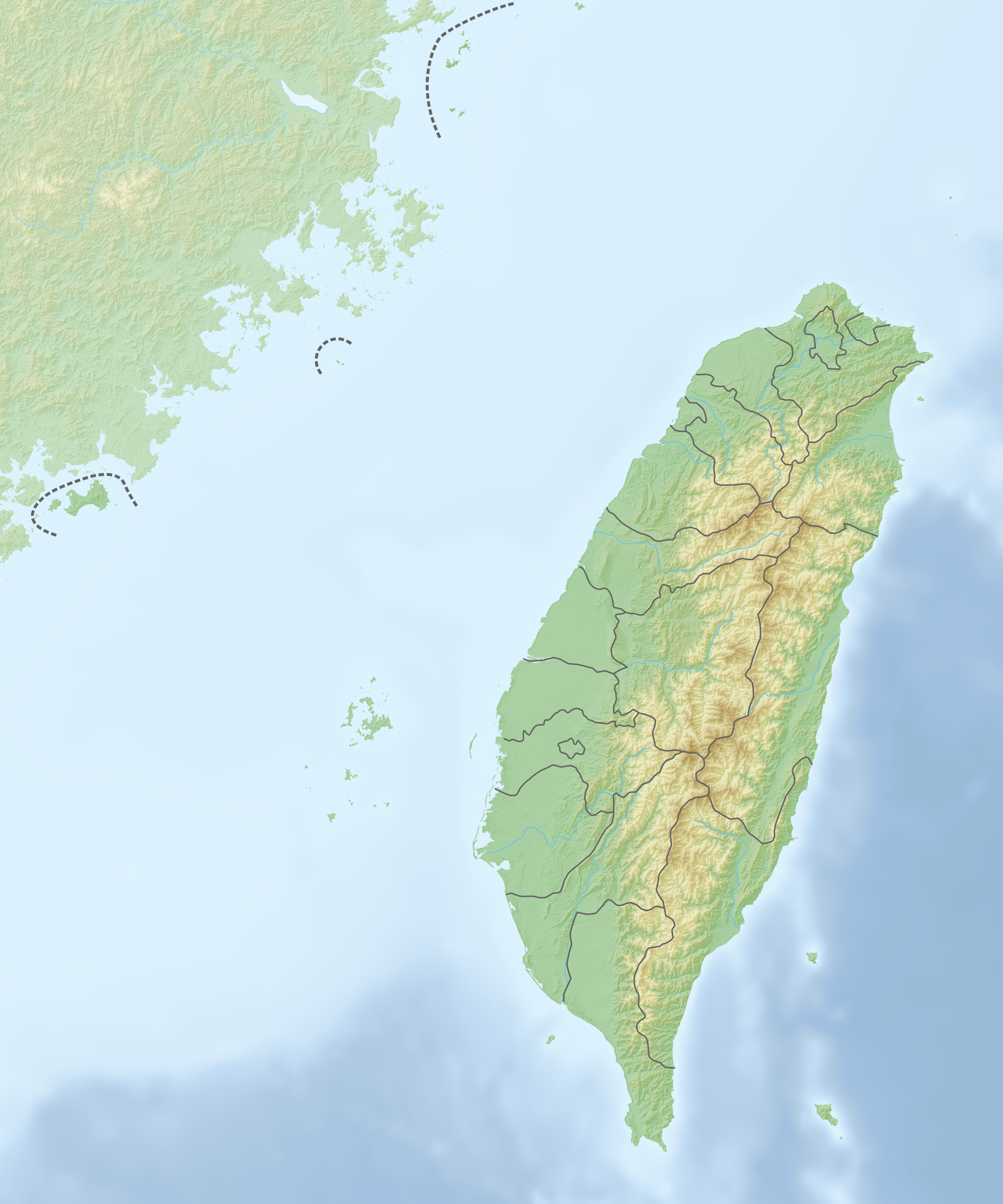
Deutsch: Reliefkarte Taiwan
Topographischer Hintergrund: NASA Shuttle Radar Topography Mission (public domain). SRTM3 v.2. |
||||||||
| Date | |||||||||
| Source | Own work | ||||||||
| Author | Tschubby | ||||||||
| Permission (Reusing this file) |
I, the copyright holder of this work, hereby publish it under the following licenses:
This file is licensed under the Creative Commons Attribution-Share Alike 2.5 Generic, 2.0 Generic and 1.0 Generic license.
You may select the license of your choice. |

File history
Click on a date/time to view the file as it appeared at that time.
| Date/Time | Thumbnail | Dimensions | User | Comment | |
|---|---|---|---|---|---|
| current | 21:01, 25 May 2018 | | 2,576 × 3,092 (4.5 MB) | Tschubby (talk | contribs) | == {{int:filedesc}} == {{Information |Description= {{de| Reliefkarte Taiwan}} Topographischer Hintergrund: [http://www2.jpl.nasa.gov/srtm NASA Shuttle Radar Topography Mission] (public domain). SRTM3 v.2.<br /> Grenzen: Taiwan location map.svg |Source={{own}} |Date= 2018-05-25 |Author= Tschubby |Permission= {{self|GFDL|Cc-by-sa-3.0-migrated|Cc-by-sa-2.5,2.0,1.0}} |other_versions= }} Category:Location maps of Taiwan |
You cannot overwrite this file.
File usage on Commons
There are no pages that use this file.
File usage on other wikis
The following other wikis use this file:
- Usage on bg.wikipedia.org
- Usage on crh.wikipedia.org
- Usage on da.wikipedia.org
- Usage on de.wikipedia.org
- Yushan (Berg)
- Deji-Talsperre
- Hehuanshan
- Sonne-Mond-See
- Vorlage:Positionskarte Taiwan
- Wikipedia:Kartenwerkstatt/Positionskarten/Asien
- Xueshan
- Mingtan-Talsperre
- Guishan Dao
- Shoushan (Kaohsiung)
- Banpingshan
- Shimen-Talsperre
- Feicui-Talsperre
- Jiji-Erdbeben
- Republik China (Taiwan)
- Liste von Kraftwerken in Taiwan
- Erdbeben in Kaohsiung 2016
- Tau (Volk)
- Hengchun-Erdbeben 2006
- Pengjia Yu
- Hualien-Erdbeben 2018
- Benutzer:Tschubby/Reliefkarten
- Liste der Kernkraftwerke in Taiwan
- Nan Wan
- Shifen Da Pubu
- Alishan-Gebirge
- Benutzer:Shi Annan/Yushan
- Benutzer:Shi Annan/Mount Nanhu
- Hualien-Erdbeben 2024
- Usage on hu.wiktionary.org
- Usage on lv.wikipedia.org
- Usage on mn.wikipedia.org
View more global usage of this file.