File:Reliefkarte Katar.png
Jump to navigation
Jump to search

Size of this preview: 625 × 599 pixels. Other resolutions: 250 × 240 pixels | 501 × 480 pixels | 801 × 768 pixels | 1,068 × 1,024 pixels | 1,460 × 1,400 pixels.
Original file (1,460 × 1,400 pixels, file size: 1.5 MB, MIME type: image/png)
Captions
Captions
Add a one-line explanation of what this file represents
Summary
[edit]| Description |
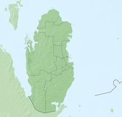
Deutsch: Reliefkarte Katar
Topographischer Hintergrund: NASA Shuttle Radar Topography Mission (public domain). SRTM3 v.2. |
||||||||
| Date | |||||||||
| Source | Own work | ||||||||
| Author | Tschubby | ||||||||
| Permission (Reusing this file) |
I, the copyright holder of this work, hereby publish it under the following licenses:
This file is licensed under the Creative Commons Attribution-Share Alike 2.5 Generic, 2.0 Generic and 1.0 Generic license.
You may select the license of your choice. |

File history
Click on a date/time to view the file as it appeared at that time.
| Date/Time | Thumbnail | Dimensions | User | Comment | |
|---|---|---|---|---|---|
| current | 17:16, 27 May 2018 | | 1,460 × 1,400 (1.5 MB) | Tschubby (talk | contribs) | {{Information |description= |source= |date= |author= |permission= |other versions= }} |
| 17:03, 27 May 2018 |  | 1,460 × 1,400 (1.5 MB) | Tschubby (talk | contribs) | == {{int:filedesc}} == {{Information |Description= {{de| Reliefkarte Katar}} Topographischer Hintergrund: [http://www2.jpl.nasa.gov/srtm NASA Shuttle Radar Topography Mission] (public domain). SRTM3 v.2.<br /> Grenzen: Qatar adm location map.svg |Source={{own}} |Date= 2018-05-27 |Author= Tschubby |Permission= {{self|GFDL|Cc-by-sa-3.0-migrated|Cc-by-sa-2.5,2.0,1.0}} |other_versions= }} Category:Location maps of Qatar |
You cannot overwrite this file.
File usage on Commons
There are no pages that use this file.
File usage on other wikis
The following other wikis use this file:
- Usage on bg.wikipedia.org
- Usage on de.wikipedia.org
- Usage on en.wikipedia.org
- Usage on eo.wikipedia.org
- Kataro
- Doho
- Ŝablono:Geokesto lokumilo Kataro
- Ŝablono:Situo sur mapo Kataro
- Mathaf: Araba Muzeo de Moderna Arto
- Metroo de Doho
- Ŝablono:Situo sur mapo Kataro Doho
- Nacia Biblioteko de Kataro
- Education City
- Scienca kaj Teknologia Parko de Kataro
- Ŝablono:Informkesto biblioteko
- Ŝablono:Informkesto biblioteko/dokumentado
- Al Reem biosfera rezervejo
- Teksasa A&M-Universitato ĉe Kataro
- Usage on es.wikipedia.org
- Usage on et.wikipedia.org
- Usage on fr.wikipedia.org
- Usage on he.wikipedia.org
- Usage on hr.wikipedia.org
- Usage on ko.wikipedia.org
- Usage on lld.wikipedia.org
- Usage on th.wikipedia.org
- Usage on uk.wikipedia.org