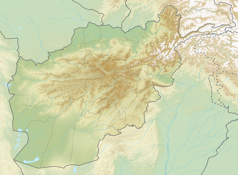
File:Reliefkarte Afghanistan.png

Original file (3,000 × 2,210 pixels, file size: 9 MB, MIME type: image/png)
Captions
Captions
Summary
[edit]| DescriptionReliefkarte Afghanistan.png |
Deutsch: Reliefkarte Afghanistan
Topographischer Hintergrund: NASA Shuttle Radar Topography Mission (public domain). SRTM3 v.2. |
||||||||
| Date | |||||||||
| Source | Own work | ||||||||
| Author | Tschubby | ||||||||
| Permission (Reusing this file) |
I, the copyright holder of this work, hereby publish it under the following licenses:
This file is licensed under the Creative Commons Attribution-Share Alike 2.5 Generic, 2.0 Generic and 1.0 Generic license.
You may select the license of your choice. |
File history
Click on a date/time to view the file as it appeared at that time.
| Date/Time | Thumbnail | Dimensions | User | Comment | |
|---|---|---|---|---|---|
| current | 19:03, 6 July 2019 |  | 3,000 × 2,210 (9 MB) | Toghrul R (talk | contribs) | aspect ratio fix to match svg version |
| 04:39, 23 May 2018 |  | 2,864 × 2,210 (8.67 MB) | Tschubby (talk | contribs) | {{Information |description= |source= |date= |author= |permission= |other versions= }} | |
| 22:50, 22 May 2018 |  | 2,864 × 2,210 (8.51 MB) | Tschubby (talk | contribs) | == {{int:filedesc}} == {{Information |Description= {{de| Reliefkarte Afghanistan}} Topographischer Hintergrund: [http://www2.jpl.nasa.gov/srtm NASA Shuttle Radar Topography Mission] (public domain). SRTM3 v.2.<br /> Grenzen: Afghanistan adm location map.svg |Source={{own}} |Date= 2018-05-23 |Author= Tschubby |Permission= {{self|GFDL|Cc-by-sa-3.0-migrated|Cc-by-sa-2.5,2.0,1.0}} |other_versions= }} [[Category:Location maps of Afg... |
You cannot overwrite this file.
File usage on Commons
There are no pages that use this file.
File usage on other wikis
The following other wikis use this file:
- Usage on ar.wikipedia.org
- Usage on arz.wikipedia.org
- Usage on az.wikipedia.org
- Usage on bg.wikipedia.org
- Хайберски проход
- Балх
- Кабул
- Херат
- Кандахар
- Мазари Шариф
- Шаблон:ПК Афганистан
- Шаблон:Река
- Файзабад
- Бамян (град)
- Асадабад
- Кундуз
- Каян
- Шаблон:Река/doc
- Джелалабад
- Лашкар Гах
- Талукан
- Пули Хумри
- Буди от Бамян
- Мургаб
- Херируд
- Културен ландшафт и археологични останки в Бамиянската долина
- Банд-е Амир
- Кашан (река)
- Кушка (река)
- Газни
- Кабул (река)
- Ношак
- Хамун
- Паропамиз
- Сефид Хук
- Банди Туркестан
- Средноафгански планини
- Баба (хребет)
- Сиахкох
- Бактрийска равнина
View more global usage of this file.
Metadata
This file contains additional information such as Exif metadata which may have been added by the digital camera, scanner, or software program used to create or digitize it. If the file has been modified from its original state, some details such as the timestamp may not fully reflect those of the original file. The timestamp is only as accurate as the clock in the camera, and it may be completely wrong.
| Software used | Adobe Photoshop CC 2018 (Windows) |
|---|---|
| Date and time of digitizing | 00:59, 7 July 2019 |
| File change date and time | 01:00, 7 July 2019 |
| Date metadata was last modified | 01:00, 7 July 2019 |
| Unique ID of original document | xmp.did:0272c34c-3931-604d-bfd8-a09976f3c046 |
| Horizontal resolution | 118.11 dpc |
| Vertical resolution | 118.11 dpc |

