File:Relief Map of Taymyrsky District.png
Jump to navigation
Jump to search
Size of this preview: 473 × 599 pixels. Other resolutions: 189 × 240 pixels | 379 × 480 pixels | 675 × 855 pixels.
Original file (675 × 855 pixels, file size: 882 KB, MIME type: image/png)
Captions
Captions
Add a one-line explanation of what this file represents
Summary
[edit]| Description |
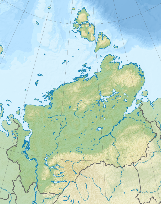
Русский: Физическая карта Таймырского Долгано-Ненецкого района Красноярского края.
English: Relief map of Taymyrsky Dolgano-Nenetsky District.
Equidistant conic projection.
|
| Date | |
| Source |
|
| Author | Nzeemin |
| Other versions |
|

Licensing
[edit]
I, the copyright holder of this work, hereby publish it under the following license:
This file is licensed under the Creative Commons Attribution-Share Alike 3.0 Unported license.
- You are free:
- to share – to copy, distribute and transmit the work
- to remix – to adapt the work
- Under the following conditions:
- attribution – You must give appropriate credit, provide a link to the license, and indicate if changes were made. You may do so in any reasonable manner, but not in any way that suggests the licensor endorses you or your use.
- share alike – If you remix, transform, or build upon the material, you must distribute your contributions under the same or compatible license as the original.
File history
Click on a date/time to view the file as it appeared at that time.
| Date/Time | Thumbnail | Dimensions | User | Comment | |
|---|---|---|---|---|---|
| current | 16:06, 18 September 2012 | | 675 × 855 (882 KB) | Nzeemin (talk | contribs) | User created page with UploadWizard |
You cannot overwrite this file.
File usage on Commons
The following page uses this file:
File usage on other wikis
The following other wikis use this file:
- Usage on ce.wikipedia.org
- Usage on en.wikipedia.org
- Usage on fi.wikipedia.org
- Usage on fr.wikipedia.org
- Île Komsomolets
- Péninsule de Taïmyr
- Île Bolchevique
- Golfe de Khatanga
- Île Taïmyr
- Golfe de l'Ienisseï
- Cap Tcheliouskine
- Archipel Nordenskiöld
- Réserve naturelle du Grand Arctique
- Lac Taïmyr
- Péninsule de Gydan
- Golfe de Taïmyr
- Forêt de Loukounski
- Ary-Mas
- Modèle:Géolocalisation/Raïon dolgano-nénètse de Taïmyr
- Modèle:Géolocalisation/Raïon dolgano-nénètse de Taïmyr/Documentation
- Usage on hr.wikipedia.org
- Usage on kk.wikipedia.org
- Usage on lv.wikipedia.org
- Taimiras ezers
- Taimira
- Čeļuskina rags
- Severnaja Zemļa
- Ušakova sala
- Ostrovušakova
- Vīzes sala
- Vīze (polārstacija)
- Modulis:VietasKarte/dati/Taimiras Dolganu-Ņencu rajons
- Modulis:VietasKarte/dati/Taimiras Dolganu-Ņencu rajons/doc
- Ujediņeņijas sala
- Ujediņeņija
- Sergeja Kirova salas
- Isačenko sala
- Isačenko (polārstacija)
- Voroņina sala
- Izvestijas CIK salas
- Izvestija CIK
- Arktikas Institūta salas
View more global usage of this file.