File:Rekisterikylät - Paattinen (1968).png
Jump to navigation
Jump to search

Size of this preview: 253 × 599 pixels. Other resolutions: 101 × 240 pixels | 202 × 480 pixels | 324 × 768 pixels | 432 × 1,024 pixels | 1,740 × 4,122 pixels.
Original file (1,740 × 4,122 pixels, file size: 469 KB, MIME type: image/png)
Captions
Captions
Add a one-line explanation of what this file represents
Summary
[edit].png&action=edit§ion=1)
| Description |
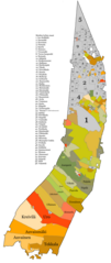
English: Register village borders of Paattinen in 1968. White areas represent shared or unclear lands.
Source: Maanmittauslaitos, Vanhat painetut kartat (https://vanhatpainetutkartat.maanmittauslaitos.fi/), select "Peruskartta 1:20 000" and download to see the maps.
Suomi: Paattisten rekisterikylät vuonna 1968. Valkoiset alueet ovat joko yhteisiä tai epäselviä alueita.
Lähteenä Maanmittauslaitoksen vanhat peruskartat, saatavilla Vanhat painetut kartat- palvelusta (Peruskartta 1:20 000). |
| Date | |
| Source | Own work |
| Author | Kapulakone |
Licensing
[edit].png&action=edit§ion=2)
I, the copyright holder of this work, hereby publish it under the following license:
This file is licensed under the Creative Commons Attribution-Share Alike 4.0 International license.
- You are free:
- to share – to copy, distribute and transmit the work
- to remix – to adapt the work
- Under the following conditions:
- attribution – You must give appropriate credit, provide a link to the license, and indicate if changes were made. You may do so in any reasonable manner, but not in any way that suggests the licensor endorses you or your use.
- share alike – If you remix, transform, or build upon the material, you must distribute your contributions under the same or compatible license as the original.
File history
Click on a date/time to view the file as it appeared at that time.
| Date/Time | Thumbnail | Dimensions | User | Comment | |
|---|---|---|---|---|---|
| current | 09:25, 11 August 2023 | | 1,740 × 4,122 (469 KB) | Kapulakone (talk | contribs) | Uploaded own work with UploadWizard |
You cannot overwrite this file.
File usage on Commons
There are no pages that use this file.
.png&oldid=792277079)