File:Regiones naturales del Perú.png
Jump to navigation
Jump to search

Size of this preview: 467 × 599 pixels. Other resolutions: 187 × 240 pixels | 374 × 480 pixels | 599 × 768 pixels | 798 × 1,024 pixels | 1,806 × 2,317 pixels.
Original file (1,806 × 2,317 pixels, file size: 848 KB, MIME type: image/png)
Captions
Captions
Add a one-line explanation of what this file represents
Summary
[edit]
| Description |
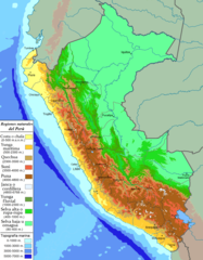
Español: Mapa de las regiones naturales y altitudinales del Perú, de acuerdo con los parámetros de Javier Pulgar Vidal (1938). |
| Date | |
| Source | Own work |
| Author | Maulucioni |
Mapa basado en los parámetros de Javier Pulgar Vidal (Atlas del Perú, 1989. pag. 108 Instituto Geográfico Nacional, Lima-Perú). La información topográfica se toma de File:Peru physical map.svg (Misión topográfica Radar Shuttle) y Google Earth.
Licensing
[edit]
I, the copyright holder of this work, hereby publish it under the following license:
This file is licensed under the Creative Commons Attribution-Share Alike 4.0 International license.
- You are free:
- to share – to copy, distribute and transmit the work
- to remix – to adapt the work
- Under the following conditions:
- attribution – You must give appropriate credit, provide a link to the license, and indicate if changes were made. You may do so in any reasonable manner, but not in any way that suggests the licensor endorses you or your use.
- share alike – If you remix, transform, or build upon the material, you must distribute your contributions under the same or compatible license as the original.
File history
Click on a date/time to view the file as it appeared at that time.
| Date/Time | Thumbnail | Dimensions | User | Comment | |
|---|---|---|---|---|---|
| current | 21:33, 4 August 2019 | | 1,806 × 2,317 (848 KB) | Maulucioni (talk | contribs) | Cambios menores |
| 17:01, 19 March 2019 |  | 1,806 × 2,317 (851 KB) | Maulucioni (talk | contribs) | Añado ciudades. | |
| 05:30, 15 March 2019 |  | 1,808 × 2,317 (847 KB) | Maulucioni (talk | contribs) | User created page with UploadWizard |
You cannot overwrite this file.
File usage on Commons
There are no pages that use this file.
File usage on other wikis
The following other wikis use this file:
- Usage on ast.wikipedia.org
- Usage on en.wikipedia.org
- Usage on en.wikivoyage.org
- Usage on es.wikipedia.org
- Usage on es.wikivoyage.org
- Usage on fr.wikivoyage.org
- Usage on pt.wikipedia.org
- Usage on ru.wikipedia.org