File:Region Grabfeld.png
Jump to navigation
Jump to search

Size of this preview: 800 × 554 pixels. Other resolutions: 320 × 222 pixels | 640 × 443 pixels | 1,024 × 709 pixels | 1,280 × 887 pixels | 1,500 × 1,039 pixels.
Original file (1,500 × 1,039 pixels, file size: 2.05 MB, MIME type: image/png)
Captions
Captions
Add a one-line explanation of what this file represents
Summary
[edit]
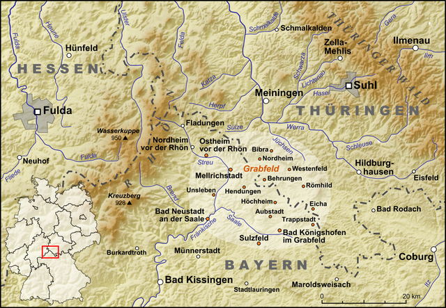
| Description | Die Region de:Grabfeld |
| Date | |
| Source |
own work, used:
|
| Author | Lencer |

|
This map has been made or improved in the German Kartenwerkstatt (Map Lab). You can propose maps to improve as well.
|
Licensing
[edit]
I, the copyright holder of this work, hereby publish it under the following license:
This file is licensed under the Creative Commons Attribution-Share Alike 3.0 Unported license.
- You are free:
- to share – to copy, distribute and transmit the work
- to remix – to adapt the work
- Under the following conditions:
- attribution – You must give appropriate credit, provide a link to the license, and indicate if changes were made. You may do so in any reasonable manner, but not in any way that suggests the licensor endorses you or your use.
- share alike – If you remix, transform, or build upon the material, you must distribute your contributions under the same or compatible license as the original.
File history
Click on a date/time to view the file as it appeared at that time.
| Date/Time | Thumbnail | Dimensions | User | Comment | |
|---|---|---|---|---|---|
| current | 19:41, 12 August 2008 | | 1,500 × 1,039 (2.05 MB) | Lencer (talk | contribs) | {{Information |Description= |Source= |Date= |Author= |Permission= |other_versions= }} |
| 19:29, 12 August 2008 |  | 1,500 × 1,039 (2.05 MB) | Lencer (talk | contribs) | == Beschreibung == {{Information |Description=Die Werra und ihre Nebenflüsse |Source=own work, used: * http://www.openstreetmap.org * [http://www2.demis.nl/wms/mapclip.htm Demis Webserver] * Generic Mapping Tools |Date=August 2008 |Author=[ |
You cannot overwrite this file.
File usage on Commons
There are no pages that use this file.
File usage on other wikis
The following other wikis use this file:
- Usage on cs.wikipedia.org
- Usage on de.wikipedia.org
- Usage on en.wikipedia.org
- Usage on incubator.wikimedia.org
- Usage on nl.wikipedia.org
- Usage on pl.wikivoyage.org
- Usage on ru.wikipedia.org