File:Regierungsbezirke Deutschlands 1981-2008.svg
Jump to navigation
Jump to search

Size of this PNG preview of this SVG file: 439 × 599 pixels. Other resolutions: 176 × 240 pixels | 352 × 480 pixels | 563 × 768 pixels | 750 × 1,024 pixels | 1,500 × 2,048 pixels | 1,351 × 1,844 pixels.
Original file (SVG file, nominally 1,351 × 1,844 pixels, file size: 1.5 MB)
Captions
Captions
Add a one-line explanation of what this file represents
Summary
[edit]
| Description |
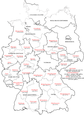
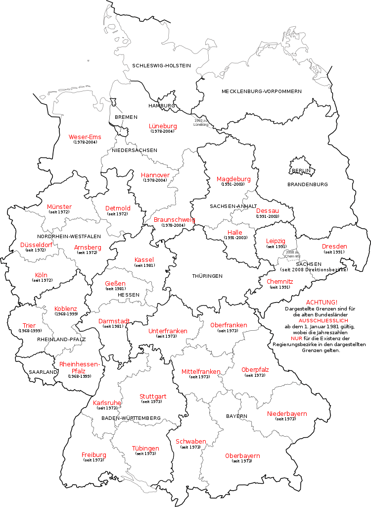
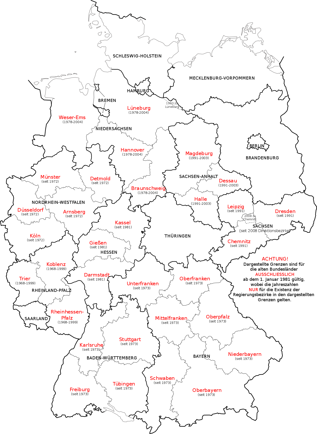
Deutsch: Karte der deutschen Regierungsbezirke und Direktsionsbezirke sowie ehemaliger Regierungsbezirke in Niedersachsen, Sachsen-Anhalt und Rheinland-Pfalz.
English: Map in German language of Germany showing the boundaries of the Regierungsbezirke for FRG from January 1st 1981 and for Germany till 2008. Also displayed are the former RB of Lower Saxony, Rhineland-Palatinate and Saxony-Anhalt.
Русский: Карта административных округов земель Германии и бывших административных округов в землях Нижней Саксонии, Саксонии, Саксонии-Ангальт и Рейнланд-Пфальц. |
| Date | |
| Source | Own work, map derived from the image Kfz-Kennzeichen Deutschlands.svg |
| Author | Bennet Schulte |
| Other versions | Derivative works of this file: Deutsche Rentenversicherung - Regionalträger 2006.svg |
Licensing
[edit]
I, the copyright holder of this work, hereby publish it under the following licenses:
This file is licensed under the Creative Commons Attribution-Share Alike 3.0 Unported license.
- You are free:
- to share – to copy, distribute and transmit the work
- to remix – to adapt the work
- Under the following conditions:
- attribution – You must give appropriate credit, provide a link to the license, and indicate if changes were made. You may do so in any reasonable manner, but not in any way that suggests the licensor endorses you or your use.
- share alike – If you remix, transform, or build upon the material, you must distribute your contributions under the same or compatible license as the original.

|
Permission is granted to copy, distribute and/or modify this document under the terms of the GNU Free Documentation License, Version 1.2 or any later version published by the Free Software Foundation; with no Invariant Sections, no Front-Cover Texts, and no Back-Cover Texts. A copy of the license is included in the section entitled GNU Free Documentation License. |
You may select the license of your choice.
File history
Click on a date/time to view the file as it appeared at that time.
| Date/Time | Thumbnail | Dimensions | User | Comment | |
|---|---|---|---|---|---|
| current | 15:23, 1 December 2017 | | 1,351 × 1,844 (1.5 MB) | Reinhard Kraasch (talk | contribs) | typo corr. |
| 14:30, 1 October 2009 |  | 1,351 × 1,844 (1.39 MB) | Exec (talk | contribs) | Amt Neuhaus eingebaut | |
| 13:19, 30 September 2009 |  | 1,351 × 1,844 (1.39 MB) | Exec (talk | contribs) | Embedded Font again | |
| 13:17, 30 September 2009 |  | 1,351 × 1,844 (183 KB) | Exec (talk | contribs) | Reverted to version as of 13:08, 30 September 2009 | |
| 13:16, 30 September 2009 |  | 1,351 × 1,844 (1.39 MB) | Exec (talk | contribs) | SVG Font embedding optimzed | |
| 13:08, 30 September 2009 |  | 1,351 × 1,844 (183 KB) | Exec (talk | contribs) | Arial Font | |
| 12:49, 30 September 2009 |  | 1,351 × 1,844 (183 KB) | Exec (talk | contribs) | {{Information |Description={{en|1=Map in German language of Germany showing the boundaries of the Regierungsbezirke for FRG from January 1st 1981 and for Germany till 2008. There are also shown the former RB of Lower Saxony, Rhineland-Palatinate and Saxon |
You cannot overwrite this file.
File usage on Commons
There are no pages that use this file.
File usage on other wikis
The following other wikis use this file:
- Usage on ast.wikipedia.org
- Usage on az.wikipedia.org
- Usage on de.wikipedia.org
- Usage on de.wiktionary.org
- Usage on el.wikipedia.org
- Usage on es.wikipedia.org
- Usage on frr.wikipedia.org
- Usage on hu.wikipedia.org
- Usage on ka.wikipedia.org
- Usage on ky.wikipedia.org
- Usage on li.wikipedia.org
- Usage on pfl.wikipedia.org
- Usage on pl.wikipedia.org
- Usage on ru.wikipedia.org
- Usage on sco.wikipedia.org
- Usage on sv.wikipedia.org
- Usage on tr.wikipedia.org
- Usage on vi.wikipedia.org