File:Rega-hydrografia2.png
Jump to navigation
Jump to search

Size of this preview: 428 × 600 pixels. Other resolutions: 171 × 240 pixels | 342 × 480 pixels | 753 × 1,055 pixels.
Original file (753 × 1,055 pixels, file size: 518 KB, MIME type: image/png)
Captions
Captions
Add a one-line explanation of what this file represents
Summary
[edit]| Description |
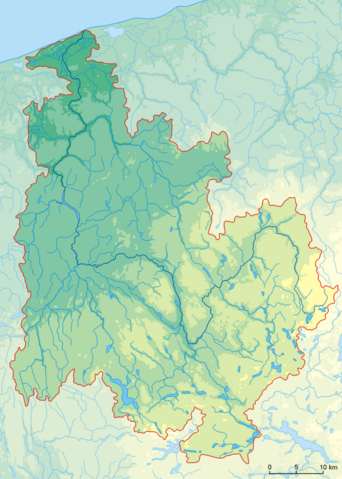
Polski: Dorzecze Regi na tle ukształtowania terenu. Zaznaczono poziomice: 20, 60, 100, 140 i 200 m |
| Date | |
| Source | Own work na podstawie map przeglądowych oraz mapy hydrograficznej Polski |
| Author | Aotearoa |
| Other versions |
|


Licensing
[edit]
I, the copyright holder of this work, hereby publish it under the following license:
This file is licensed under the Creative Commons Attribution 3.0 Unported license.
- You are free:
- to share – to copy, distribute and transmit the work
- to remix – to adapt the work
- Under the following conditions:
- attribution – You must give appropriate credit, provide a link to the license, and indicate if changes were made. You may do so in any reasonable manner, but not in any way that suggests the licensor endorses you or your use.
File history
Click on a date/time to view the file as it appeared at that time.
| Date/Time | Thumbnail | Dimensions | User | Comment | |
|---|---|---|---|---|---|
| current | 14:43, 23 November 2009 | | 753 × 1,055 (518 KB) | Aotearoa (talk | contribs) | Drobne poprawni + podziałka |
| 17:01, 20 November 2009 |  | 753 × 1,056 (475 KB) | Aotearoa (talk | contribs) | Dodany zasięg dorzecza na podstawie mapy hydrograficznej Polski | |
| 12:59, 20 November 2009 |  | 754 × 1,056 (451 KB) | Aotearoa (talk | contribs) | {{Information |Description={{en|1=k}} |Source={{own}} |Author=Aotearoa |Date= |Permission= |other_versions= }} |
You cannot overwrite this file.
File usage on Commons
The following 2 pages use this file:
File usage on other wikis
The following other wikis use this file:
- Usage on als.wikipedia.org
- Usage on be.wikipedia.org
- Usage on pl.wikipedia.org