File:Red de Cercania Barcelona.svg
Jump to navigation
Jump to search

Size of this PNG preview of this SVG file: 800 × 570 pixels. Other resolutions: 320 × 228 pixels | 640 × 456 pixels | 1,024 × 730 pixels | 1,280 × 912 pixels | 2,560 × 1,824 pixels | 1,047 × 746 pixels.
Original file (SVG file, nominally 1,047 × 746 pixels, file size: 143 KB)
Captions
Captions
Add a one-line explanation of what this file represents
Summary
[edit]
| Description |
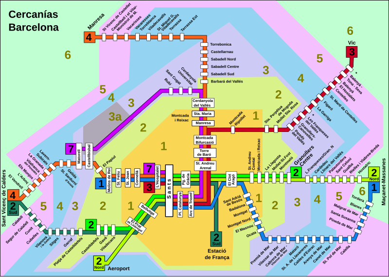
Català: Mapa de la xarxa de rodalies Barcelona, incloent les zones tarifàries.
Deutsch: Netz der Cercanias in Barcelona, mit Zoneneinteilung
English: Map of the Barcelona Renfe rail network
Español: Mapa de la red de cercanías Barcelona, incluyendo las zonas tarifárias. |
| Date | |
| Source | Own work |
| Author | Wela49 |
Licensing
[edit]
| I, the copyright holder of this work, release this work into the public domain. This applies worldwide. In some countries this may not be legally possible; if so: I grant anyone the right to use this work for any purpose, without any conditions, unless such conditions are required by law. |
File history
Click on a date/time to view the file as it appeared at that time.
| Date/Time | Thumbnail | Dimensions | User | Comment | |
|---|---|---|---|---|---|
| current | 17:12, 17 January 2010 | | 1,047 × 746 (143 KB) | Beao (talk | contribs) | Tweak. |
| 17:07, 17 January 2010 |  | 1,047 × 746 (145 KB) | Beao (talk | contribs) | Minor fix. | |
| 13:59, 14 January 2010 |  | 1,052 × 744 (166 KB) | Wela49~commonswiki (talk | contribs) | Korrektur | |
| 20:07, 30 December 2009 |  | 1,052 × 744 (138 KB) | Tryphon (talk | contribs) | Removing black rectangle. | |
| 17:34, 30 December 2009 |  | 1,052 × 744 (158 KB) | Wela49~commonswiki (talk | contribs) | Mehrere kleine Fehler korrigiert. | |
| 10:21, 30 December 2009 |  | 1,056 × 747 (139 KB) | Tryphon (talk | contribs) | Trying to remove the black rectangle. | |
| 16:28, 28 December 2009 |  | 1,056 × 747 (161 KB) | Wela49~commonswiki (talk | contribs) | {{Information |Description={{en|1=Map of Madrid suburban rail network Barcelona}} {{de|1=Netz der Cercanias in Barcelona, mit Zoneneinteilung}} {{es|1=Description Mapa de la red de Cercanías Barcelona, con zonas}} |Source={{own}} |Author=[[User:Wela49|We |
You cannot overwrite this file.
File usage on Commons
There are no pages that use this file.