File:Red Septiembre 2015.svg
Jump to navigation
Jump to search

Size of this PNG preview of this SVG file: 694 × 599 pixels. Other resolutions: 278 × 240 pixels | 556 × 480 pixels | 889 × 768 pixels | 1,186 × 1,024 pixels | 2,371 × 2,048 pixels | 1,650 × 1,425 pixels.
Original file (SVG file, nominally 1,650 × 1,425 pixels, file size: 111 KB)
Captions
Captions
Add a one-line explanation of what this file represents
Summary
[edit]
| Description |
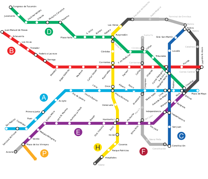
English: Current map of the Buenos Aires Underground as of December 2015. |
| Date | |
| Source | File:Subtes-2015.svg |
| Author | Galio, Segatasanshiro1 |
Licensing
[edit]

|
Permission is granted to copy, distribute and/or modify this document under the terms of the GNU Free Documentation License, Version 1.2 or any later version published by the Free Software Foundation; with no Invariant Sections, no Front-Cover Texts, and no Back-Cover Texts. A copy of the license is included in the section entitled GNU Free Documentation License. |
| This file is licensed under the Creative Commons Attribution-Share Alike 3.0 Unported license. | ||
| ||
| This licensing tag was added to this file as part of the GFDL licensing update. |
This file is licensed under the Creative Commons Attribution 2.5 Generic license.
- You are free:
- to share – to copy, distribute and transmit the work
- to remix – to adapt the work
- Under the following conditions:
- attribution – You must give appropriate credit, provide a link to the license, and indicate if changes were made. You may do so in any reasonable manner, but not in any way that suggests the licensor endorses you or your use.
File history
Click on a date/time to view the file as it appeared at that time.
| Date/Time | Thumbnail | Dimensions | User | Comment | |
|---|---|---|---|---|---|
| current | 02:57, 8 January 2016 | | 1,650 × 1,425 (111 KB) | SegataSanshiro1 (talk | contribs) | Minor fix to Line A station. |
| 02:54, 8 January 2016 |  | 1,650 × 1,425 (111 KB) | SegataSanshiro1 (talk | contribs) | Added missing phase-1 Line F segment, changed southern Line H segment to "under construction". Changed station icons to make them smaller and differentiate more clearly between regular stations and interchanges. | |
| 19:07, 18 December 2015 |  | 1,650 × 1,425 (132 KB) | SegataSanshiro1 (talk | contribs) | Line H extension | |
| 09:58, 28 September 2015 |  | 1,650 × 1,425 (131 KB) | SegataSanshiro1 (talk | contribs) | Minor fixes | |
| 20:14, 1 September 2015 |  | 1,650 × 1,425 (131 KB) | SegataSanshiro1 (talk | contribs) | User created page with UploadWizard |
You cannot overwrite this file.
File usage on Commons
The following 8 pages use this file:
- User:Chumwa/OgreBot/Public transport information/2015 December 11-20
- User:Chumwa/OgreBot/Public transport information/2015 September 1-10
- User:Chumwa/OgreBot/Public transport information/2015 September 21-30
- User:Chumwa/OgreBot/Public transport information/2016 January 1-10
- User:Chumwa/OgreBot/Transport Maps/2015 December 11-20
- User:Chumwa/OgreBot/Transport Maps/2015 September 1-10
- User:Chumwa/OgreBot/Transport Maps/2015 September 21-30
- User:Chumwa/OgreBot/Transport Maps/2016 January 1-10
File usage on other wikis
The following other wikis use this file:
- Usage on fa.wikipedia.org
- Usage on it.wikipedia.org
- Usage on ja.wikipedia.org