File:Recorrido de la prueba de ciclismo organizada por el Club Atlético Progreso (2014).png
Original file (369 × 847 pixels, file size: 287 KB, MIME type: image/png)
Captions
Captions
Summary
[edit].png&action=edit§ion=1)
| Description |
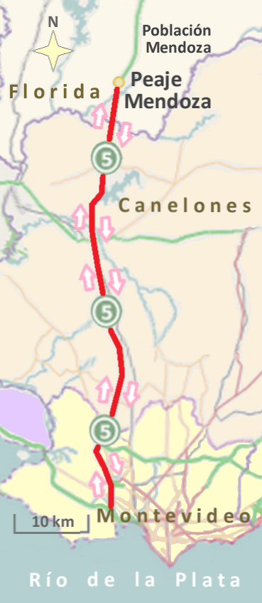
Español: La decimocuarta fecha del certamen uruguayo 2014-2015 de ciclismo masculino fue corrida entre Montevideo y el peaje Mendoza (en el departamento de Florida), con retorno a Montevideo, fundamentalmente a través de la ruta nacional 5. La extensión de la carrera fue de unos 130 kilómetros.
English: The fourteenth day of the 2014-2015 Uruguay male cycling competition was run between Montevideo and toll Mendoza (in the department of Florida), returning to Montevideo, mainly through the National Route 5. The length of the race was about 130 kilometers.
Original image: https://tools.wmflabs.org/ Modifications by Hυgo.Português: O décimo quarto dia do Uruguai 2014-2015 masculino competição de ciclismo foi executado entre Montevidéu e pedágio Mendoza (no departamento de Florida), retornando a Montevidéu, principalmente através da Estrada Nacional 5. O comprimento da corrida foi sobre 130 km.
Imagem original: https://tools.wmflabs.org/ Modificações por HυgoFrançais : Le quatorzième jour de la compétition cycliste masculine 2014-2015 Uruguay a été exécuté entre Montevideo et frais Mendoza (dans le département de Florida), le retour à Montevideo, principalement à travers la route nationale 5. La longueur de la course est d'environ 130 km.
Image d'origine: https://tools.wmflabs.org/ Modifications par Hυgo.Italiano: Il quattordicesimo giorno del concorso ciclismo maschile 2014-2015 Uruguay è stato eseguito tra il Montevideo e pedaggio Mendoza (nel dipartimento di Florida), tornando a Montevideo, principalmente attraverso la strada nazionale 5. La lunghezza della gara era di circa 130 km.
Immagine originale: https://tools.wmflabs.org/ Modifiche di HυgoNederlands: De veertiende dag van de 2014-2015 Uruguay mannelijke wielerwedstrijd werd uitgevoerd tussen Montevideo en tol Mendoza (in het departement van Florida), terug te keren naar Montevideo, voornamelijk via de Nationale Route 5. De lengte van de race was over 130 kilometer.
Oorspronkelijke afbeelding: https://tools.wmflabs.org/ Wijzigingen door HυgoDeutsch: Die vierzehnten Tag des 2014-2015 Uruguay male Radrennen zwischen Montevideo und Maut Mendoza (in der Abteilung von Florida) laufen, wieder in Montevideo, vor allem durch die National Route 5. Die Länge des Rennens war etwa 130 Kilometer.
Originalbild: https://tools.wmflabs.org/ Änderungen durch HυgoPolski: Czternasty dzień męskiej konkurencji rowerowej 2014-2015 Urugwaj był prowadzony między Montevideo i opłat Mendoza (w departamencie Florydzie), wracając do Montevideo, głównie poprzez drogi krajowej nr 5. Długość wyścigu było o 130 km.
Oryginalne zdjęcie: https://tools.wmflabs.org/ Modyfikacje by HυgoРусский: Четырнадцатый день 2014-2015 Уругвай мужской части соревнований по велоспорту был бежать между Монтевидео и платной Мендоса (в отделе Флорида), возвращаясь в Монтевидео, в основном через Национальный Маршрут 5. Длина гонки было около 130 км.
Оригинальное изображение: https://tools.wmflabs.org/ Изменения по Hυgo日本語: 2014-2015ウルグアイ男性のサイクリング競技の十四日は、主にレースの長さは約あった国道5を介して、モンテビデオに戻って、モンテビデオと(フロリダの部門の)有料メンドーサの間に実行されました130キロ。
元の画像:https://tools.wmflabs.org/ 改変によって Hυgoالعربية: تم تشغيل في اليوم الرابع عشر من 2014-2015 أوروغواي الدراجات المنافسة بين الذكور مونتيفيديو وعدد مندوزا (في قسم من ولاية فلوريدا)، والعودة الى مونتيفيديو، وذلك أساسا من خلال الطريق الوطنية 5. وكان طول السباق على وشك 130 كيلومترا.
https://tools.wmflabs.org/ :الصورة الأصلية Hυgo تعديلات من قبل |
| Date | |
| Source | https://tools.wmflabs.org/ |
| Author | © Colaboradores de OpenStreetMap. Modificaciones a cargo de Hυgo. |
Licensing
[edit].png&action=edit§ion=2)
| This work contains information from OpenStreetMap, which is made available under the Open Database License (ODbL).
The ODbL does not require any particular license for maps produced from ODbL data. Prior to 1 August 2020, map tiles produced by the OpenStreetMap Foundation were licensed under the CC-BY-SA-2.0 license. Maps produced by other people may be subject to other licences. |
- You are free:
- to share – to copy, distribute and transmit the work
- to remix – to adapt the work
- Under the following conditions:
- attribution – You must give appropriate credit, provide a link to the license, and indicate if changes were made. You may do so in any reasonable manner, but not in any way that suggests the licensor endorses you or your use.
- share alike – If you remix, transform, or build upon the material, you must distribute your contributions under the same or compatible license as the original.
File history
Click on a date/time to view the file as it appeared at that time.
| Date/Time | Thumbnail | Dimensions | User | Comment | |
|---|---|---|---|---|---|
| current | 22:55, 17 June 2015 | | 369 × 847 (287 KB) | Hυgo (talk | contribs) | Color |
| 22:53, 5 June 2015 |  | 369 × 847 (229 KB) | Hυgo (talk | contribs) | User created page with UploadWizard |
You cannot overwrite this file.
File usage on Commons
The following 2 pages use this file:
File usage on other wikis
The following other wikis use this file:
- Usage on es.wikipedia.org
.png&oldid=493332792)