File:Limited recognition map large.png

Original file (1,248 × 660 pixels, file size: 25 KB, MIME type: image/png)
Captions
Captions

|
This map image could be re-created using vector graphics as an SVG file. This has several advantages; see Commons:Media for cleanup for more information. If an SVG form of this image is available, please upload it and afterwards replace this template with
{{vector version available|new image name}}.
It is recommended to name the SVG file “Limited recognition map large.svg”—then the template Vector version available (or Vva) does not need the new image name parameter. |
| English |
|---|
|
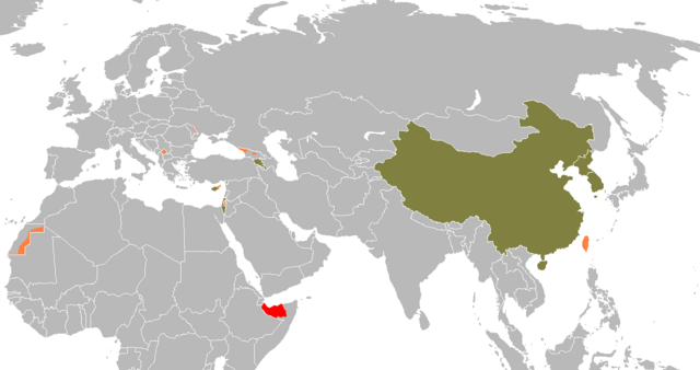
No recognition by UN member states
Limited recognition
Majority recognition
Territories whose status is disputed; with a government body that is recognized by at least a few dozen countries
Note: The governments of the PR of China and the ROC (Taiwan) both claim themselves the legitimate government of ALL China. |
| Nederlands |
|---|
|
Geen internationale erkenning
Beperkte erkenning
Erkend door de meeste landen
Gebieden waarvan de status betwist wordt, met een regering die beperkt erkend wordt
NB: De regeringen van de Volksrepubliek China en de Republiek China (Taiwan) claimen zichzelf de legitieme heerser over heel China. |
| Polski |
|---|
|
Państwa nieuznawane przez żadne niepodległe państwo
Państwa uznawane jedynie przez część krajów
Państwa uznawane przez większość, ale nie przez wszystkie państwa
Terytoria o nieustalonym statusie politycznym, których reprezentacja polityczna jest uznawana przynajmniej przez kilkadziesiąt państw
Uwaga: Zarówno ChRL, jak i Republika Chińska (Tajwan) uważają się za legalnych reprezentantów CAŁYCH Chin. |
| Deutsch |
|---|
|
Keine internationale Anerkennung
Begrenzte Anerkennung
Die meisten Länder erkennen dieses Land an
Einige Länder erkennen dieses Land an
Randbemerkung: Sowohl die Republik China (Taiwan), als auch die Volksrepublik China beanspruchen das gesamte Territorium Chinas. |
| Français |
|---|
|
Aucune reconnaissance internationale
Reconnaissance internationale limitée
Reconnu par la majorité des Etats
Territoires au statut controversé dont les autorités gouvernementales sont reconnues par au moins quelques dizaines d'Etats
Note : La République de Chine (Taïwan) et la République populaire de Chine revendiquent toutes deux la totalité du territoire chinois. |
| Türkçe |
|---|
|
Hiçbir ülke tarafından tanınmamaktadır
Sınırlı sayıda ülke tarafından tanınmaktadır
Die meisten Länder erkennen dieses Land an
Statüsü tartışılan devletler; sınırlı sayıda ülke tarafından tanınan bir hükûmete sahiptir
Not: Hem Tayvan hem de Çin Halk Cumhuriyeti kendini Çin'in hakimi olarak kabul ediyor. |
| Description |
Nederlands: Lijst van niet of gedeeltelijk erkende staten
|
| Date | |
| Source | Own work |
| Author | Robert Wielgórski (Barry Kent) |
| Other versions | Derivative works of this file: Limited recognition.png |

|
Permission is granted to copy, distribute and/or modify this document under the terms of the GNU Free Documentation License, Version 1.2 or any later version published by the Free Software Foundation; with no Invariant Sections, no Front-Cover Texts, and no Back-Cover Texts. A copy of the license is included in the section entitled GNU Free Documentation License. |
| This file is licensed under the Creative Commons Attribution-Share Alike 3.0 Unported license. | ||
| ||
| This licensing tag was added to this file as part of the GFDL licensing update. |
- You are free:
- to share – to copy, distribute and transmit the work
- to remix – to adapt the work
- Under the following conditions:
- attribution – You must give appropriate credit, provide a link to the license, and indicate if changes were made. You may do so in any reasonable manner, but not in any way that suggests the licensor endorses you or your use.
File history
Click on a date/time to view the file as it appeared at that time.
| Date/Time | Thumbnail | Dimensions | User | Comment | |
|---|---|---|---|---|---|
| current | 21:48, 5 January 2024 | | 1,248 × 660 (25 KB) | Iktsokh (talk | contribs) | Azerbaijan has regained de facto control over its internationally recognized territory (Republic of Artsakh completely ceases to exist from January 1, 2024). |
| 10:07, 4 November 2023 |  | 1,248 × 660 (35 KB) | Siirski (talk | contribs) | Reverted to version as of 00:56, 7 July 2014 (UTC) | |
| 18:24, 1 October 2023 |  | 1,248 × 660 (46 KB) | Caawiyahaderon (talk | contribs) | https://www.thehindu.com/news/international/pro-somalia-militia-takes-key-army-base-in-breakaway-region/article67238670.ece | |
| 00:56, 7 July 2014 |  | 1,248 × 660 (35 KB) | Spesh531 (talk | contribs) | area of control per all countries (so somaliland and sadr changed) border around majority recognized Kosovo, removed Crimea, Nagorno-Karabakh pink | |
| 18:12, 20 March 2014 |  | 1,248 × 661 (62 KB) | Michalg95 (talk | contribs) | krym | |
| 20:20, 8 January 2011 |  | 1,248 × 661 (56 KB) | Nicolay Sidorov (talk | contribs) | full Somaliland | |
| 23:42, 8 May 2010 |  | 1,248 × 661 (44 KB) | Roxanna (talk | contribs) | full western sahara | |
| 14:04, 3 February 2010 |  | 1,248 × 661 (33 KB) | EmilJ (talk | contribs) | fix collateral damage | |
| 11:33, 3 February 2010 |  | 1,248 × 661 (33 KB) | EmilJ (talk | contribs) | adjust Somaliland/Puntland boundary | |
| 14:46, 29 December 2009 |  | 1,248 × 661 (36 KB) | EmilJ (talk | contribs) | Liechtenstein and Slovakia normalized relations |
You cannot overwrite this file.
File usage on Commons
The following 5 pages use this file:
File usage on other wikis
The following other wikis use this file:
- Usage on az.wikipedia.org
- Usage on krc.wikipedia.org
- Usage on lt.wikipedia.org
- Usage on mr.wikipedia.org
- Usage on pl.wikipedia.org
- Mahmud Abbas
- Dyskusja:Państwo nieuznawane
- Hashim Thaçi
- Szablon:Prezydenci i premierzy państw nieuznawanych
- Jibrell Ali Salad
- Raul Chadżymba
- Ahmed M. Mahamoud Silanyo
- Anatolij Bibiłow
- Domienti Kułumbiegow
- Ibrahim Ghali
- Wadim Krasnosielski
- Muse Bihi Abdi
- Lai Ching‑te
- Ersin Tatar
- Ünal Üstel
- Aleksandr Rozenberg
- Konstantin Dżusojew
- Usage on su.wikipedia.org
- Usage on sv.wikipedia.org
- Usage on ta.wikipedia.org
- Usage on tt.wikipedia.org