File:Rear map.jpg
Jump to navigation
Jump to search

Size of this preview: 800 × 588 pixels. Other resolutions: 320 × 235 pixels | 640 × 470 pixels | 1,024 × 752 pixels | 1,280 × 940 pixels | 2,201 × 1,617 pixels.
Original file (2,201 × 1,617 pixels, file size: 1.61 MB, MIME type: image/jpeg)
Captions
Captions
Add a one-line explanation of what this file represents
Summary
[edit]
| Description |
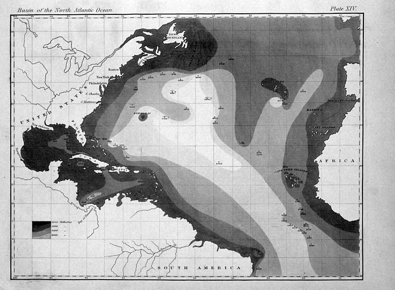
English: "The very earliest rendition of a bathymetric map of an oceanic basin. Matthew Fontaine Maury published this map in 1853 in Explanations and Sailing Directions to Accompany the Wind and Current Charts." |
| Date | |
| Source |
http://oceanexplorer.noaa.gov/history/readings/vicissitudes/media/gulf.html |
| Author | Matthew Fontaine Maury |
Licensing
[edit]
This image is in the public domain because it contains materials that originally came from the U.S. National Oceanic and Atmospheric Administration, taken or made as part of an employee's official duties.
|
|
This work is in the public domain in its country of origin and other countries and areas where the copyright term is the author's life plus 70 years or fewer. | |
| This file has been identified as being free of known restrictions under copyright law, including all related and neighboring rights. | |
File history
Click on a date/time to view the file as it appeared at that time.
| Date/Time | Thumbnail | Dimensions | User | Comment | |
|---|---|---|---|---|---|
| current | 16:31, 6 August 2011 | | 2,201 × 1,617 (1.61 MB) | Belg4mit (talk | contribs) | {{Information |Description ={{en|1="The very earliest rendition of a bathymetric map of an oceanic basin. Matthew Fontaine Maury published this map in 1853 in ''Explanations and Sailing Directions to Accompany the Wind and Current Charts''."}} |Sou |
You cannot overwrite this file.
File usage on Commons
There are no pages that use this file.
File usage on other wikis
The following other wikis use this file:
- Usage on bg.wikipedia.org
- Usage on en.wikipedia.org
- Usage on eo.wikipedia.org
- Usage on fa.wikipedia.org
- Usage on fr.wikipedia.org
- Usage on mk.wikipedia.org
- Usage on pt.wikipedia.org
- Usage on tr.wikipedia.org
- Usage on zh.wikipedia.org