File:Rb-map-hr.png
Jump to navigation
Jump to search
No higher resolution available.
Rb-map-hr.png (328 × 352 pixels, file size: 17 KB, MIME type: image/png)
Captions
Captions
Add a one-line explanation of what this file represents
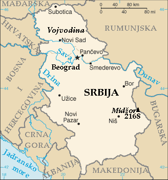
| Description | Map of the Republic of Serbia (FIPS 10 country code standard: RB) | |||
| Date | ||||
| Source | The World Factbook (published by CIA in 2008). | |||
| Author | Central Intelligence Agency of the Government of the United States of America | |||
| Permission (Reusing this file) |
|
|||
| Other versions | Image:Rb-map.png (English version). |

File history
Click on a date/time to view the file as it appeared at that time.
| Date/Time | Thumbnail | Dimensions | User | Comment | |
|---|---|---|---|---|---|
| current | 18:20, 5 November 2010 | | 328 × 352 (17 KB) | Pokrajac (talk | contribs) | Reverted to version as of 22:39, 19 November 2009 |
| 23:49, 17 March 2010 |  | 328 × 352 (17 KB) | Bugoslav (talk | contribs) | Reverted to version as of 23:47, 17 March 2010 4th time is the charm. | |
| 23:48, 17 March 2010 |  | 328 × 352 (17 KB) | Bugoslav (talk | contribs) | Reverted to version as of 23:21, 16 October 2009 I hope that the file would finally be at its orriginal position, as first uploaded. | |
| 23:47, 17 March 2010 |  | 328 × 352 (17 KB) | Bugoslav (talk | contribs) | Reverted to version as of 23:21, 16 October 2009 Pokrajac and Boksi should upload their own maps, if they want to use them, they should leave this one alone. | |
| 23:46, 17 March 2010 |  | 328 × 352 (17 KB) | Bugoslav (talk | contribs) | Reverted to version as of 23:21, 16 October 2009 Please leave the map alone, we need different sittuation maps for different articles, at different languages. | |
| 22:39, 19 November 2009 |  | 328 × 352 (17 KB) | Pokrajac (talk | contribs) | Reverted to version as of 18:04, 16 October 2009 | |
| 23:21, 16 October 2009 |  | 328 × 352 (17 KB) | Bugoslav (talk | contribs) | Reverted to version as of 00:37, 4 January 2009 Boksi and Pokrajac should leave this file alone. They have plenty other files that agree with their POV. | |
| 18:04, 16 October 2009 |  | 328 × 352 (17 KB) | Pokrajac (talk | contribs) | Reverted to version as of 13:21, 1 January 2009 | |
| 00:37, 4 January 2009 |  | 328 × 352 (17 KB) | Hcafnie (talk | contribs) | Reverted to version as of 00:34, 4 January 2009 | |
| 00:34, 4 January 2009 |  | 328 × 352 (17 KB) | Hcafnie (talk | contribs) | Reverted to version as of 17:40, 17 February 2008 |
You cannot overwrite this file.
File usage on Commons
There are no pages that use this file.