File:Rava bays satelite.gif
Jump to navigation
Jump to search

Size of this preview: 460 × 599 pixels. Other resolutions: 184 × 240 pixels | 462 × 602 pixels.
Original file (462 × 602 pixels, file size: 108 KB, MIME type: image/gif, 0.1 s)
Captions
Captions
Add a one-line explanation of what this file represents
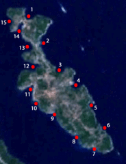
| Description | Satelite image of island Rava with marked bays. |
| Date | (UTC) |
| Source | |
| Author |
|
| This is a retouched picture, which means that it has been digitally altered from its original version. The original can be viewed here: Rava satelite.gif:
|
| This image is in the public domain because it is a screenshot from NASA’s globe software World Wind using a public domain layer, such as Blue Marble, MODIS, Landsat, SRTM, USGS or GLOBE.
|
 |
Original upload log
[edit]
This image is a derivative work of the following images:
- File:Rava_satelite.gif licensed with PD-WorldWind
- 2006-09-17T13:58:00Z Dijxtra 462x602 (133746 Bytes) Satelite image of island [[:en:Rava (island)|Rava]]. {{PD-WorldWind}} [[Category:Satelite images of islands of Croatia]]
Uploaded with derivativeFX
File history
Click on a date/time to view the file as it appeared at that time.
| Date/Time | Thumbnail | Dimensions | User | Comment | |
|---|---|---|---|---|---|
| current | 16:43, 22 August 2010 | | 462 × 602 (108 KB) | Mate Mavar (talk | contribs) | {{Information |Description=Satelite image of island Rava with marked bays. |Source=*File:Rava_satelite.gif |Date=2010-08-22 16:40 (UTC) |Author=*File:Rava_satelite.gif: NASA *derivative work: ~~~ |Permission= |other_versio |
You cannot overwrite this file.
File usage on Commons
There are no pages that use this file.
File usage on other wikis
The following other wikis use this file:
- Usage on az.wikipedia.org
- Usage on hr.wikipedia.org
- Usage on hu.wikipedia.org
- Usage on hy.wikipedia.org
- Usage on it.wikipedia.org
- Usage on ru.wikipedia.org
- Usage on uk.wikipedia.org