File:Rashi, תרשים סכמטי של אי (FL6879341 2369253).jpg
Jump to navigation
Jump to search

Size of this preview: 488 × 599 pixels. Other resolutions: 195 × 240 pixels | 391 × 480 pixels | 626 × 768 pixels | 834 × 1,024 pixels | 2,040 × 2,504 pixels.
Original file (2,040 × 2,504 pixels, file size: 2.09 MB, MIME type: image/jpeg)
Captions
Captions
Add a one-line explanation of what this file represents
Summary
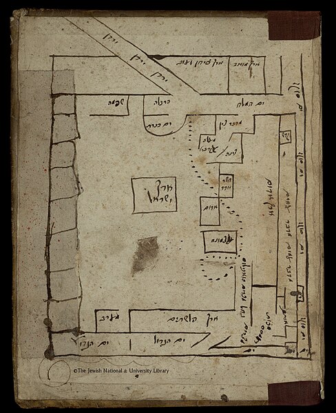
[edit]| Rashi: תרשים סכמטי של אי
( |
||||||||||||||||||||||||
|---|---|---|---|---|---|---|---|---|---|---|---|---|---|---|---|---|---|---|---|---|---|---|---|---|
| Artist |
| |||||||||||||||||||||||
| Contributors | Kass, Abraham ben Joseph from Pincsow | |||||||||||||||||||||||
| Title |
תרשים סכמטי של אי |
|||||||||||||||||||||||
| Description |
תרשים סכמטי של אי. |
|||||||||||||||||||||||
| Language | Hebrew | |||||||||||||||||||||||
| Publication date | 1669 | |||||||||||||||||||||||
| Dimensions | height: 154 mm (6.06 in); width: 135 mm (5.31 in) | |||||||||||||||||||||||
| Collection |
|
|||||||||||||||||||||||
| Current location |
|
|||||||||||||||||||||||
| Place of publication | Pińczów | |||||||||||||||||||||||
| search Merhav catalog | Pińczów | |||||||||||||||||||||||
| Notes | Compiled by Abraham ben Joseph Kass from Pinczow, Poland; Manuscript; מתוך: תולדות אברהם, חובר עי אברהם בן יוסף קס מפינזאו פולין, 1669. בסוף הספר, על לוח הכריכה הפנימי. המפה המקורית בעקבות ר' אליה מזרחי שפורסמה לראשונה בונציה, 1523 (פרוש על התורה) והתבססה על הערות רשי לפרשת אלה מסעי, ספר במדבר. Ms. Heb. 1397=28; מפת אליה מזרחי נחשבת להיות המפה העברית המודפסת הראשונה | |||||||||||||||||||||||
| IE PID | IE6879339 | |||||||||||||||||||||||
| Rosetta filename | FL6879341 | |||||||||||||||||||||||
| NNL item ID (P3959) | 990023692530205171 | |||||||||||||||||||||||
| search Merhav catalog | Hebrew, Rashi | |||||||||||||||||||||||
| Source/Photographer |
|
|||||||||||||||||||||||
| Other versions | ||||||||||||||||||||||||
| Jpg / Tif version |
|
|||||||||||||||||||||||


.jpg)

.jpg&action=edit§ion=1)
Licensing
[edit].jpg&action=edit§ion=2)
The copyright situation of this work is theoretically uncertain, because in the country of origin copyright lasts 70 years after the death of the author, and the date of the author's death is unknown. However, the date of creation of the work was over 120 years ago, and it is thus a reasonable assumption that the copyright has expired (see here for the community discussion). Do not use this template if the date of death of the author is known.
| |
| This file has been identified as being free of known restrictions under copyright law, including all related and neighboring rights. | |
File history
Click on a date/time to view the file as it appeared at that time.
| Date/Time | Thumbnail | Dimensions | User | Comment | |
|---|---|---|---|---|---|
| current | 05:17, 29 July 2023 | | 2,040 × 2,504 (2.09 MB) | Geagea (talk | contribs) | pattypan 22.03 |
You cannot overwrite this file.
File usage on Commons
The following 2 pages use this file:
.jpg&oldid=788036044)