File:Rapperswil - Zerstörung 1350 - Chronik Stumpf 1547-48.jpg

Original file (3,790 × 1,800 pixels, file size: 3.69 MB, MIME type: image/jpeg)
Captions
Captions
Summary
[edit]
| Description |
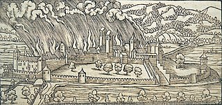
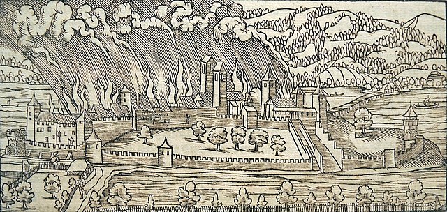
Deutsch: Rapperswil : Brandschatzung von Rapperswil (1350) an S. Matthis abend, durch Rudolf Brun. Holzschnitt aus der Stumpf'schen Chronik 1547/48. Dies ist die älteste Nordansicht der Stadt. Wahrscheinlich von Rudolf Wyssenbach nach einer Zeichnung von Hans Asper als Holzschnitt angefertigt (Theorie von Bernhard Anderes).
Brandschautzung Rapperswil 1350 [missverständliche Passagen mit ? angemerkt] English: Rapperswil-Jona : Rudolf Brun destroyed Rapperswil 1350, 'Stumpf'sche Chronik 1547/48' |
| Date | 1547/48 |
| Source | Gemeiner loblicher Eydgnoschafft Stetten, Landen und Voelckeren Chronick wirdiger thaaten Beschreybung (Stumpfsche Chronik) |
| Author | Rudolf Wyssenbach (?); upload by Roland zh 15:30, 26 April 2008 (UTC) bzw. sidonius 16:35, 29 April 2008 (UTC) |
| Other versions |
 |
| Camera location | | View this and other nearby images on: OpenStreetMap |
|---|
Licensing
[edit]
|
This work is in the public domain in its country of origin and other countries and areas where the copyright term is the author's life plus 70 years or fewer.
| |
| This file has been identified as being free of known restrictions under copyright law, including all related and neighboring rights. | |
File history
Click on a date/time to view the file as it appeared at that time.
| Date/Time | Thumbnail | Dimensions | User | Comment | |
|---|---|---|---|---|---|
| current | 18:43, 9 October 2013 | | 3,790 × 1,800 (3.69 MB) | Roland zh (talk | contribs) | aktualisiert: Stadtmuseum Rapperswil - 'Stadt in Sicht - Rapperswil in Bildern' |
| 16:30, 29 April 2008 |  | 1,826 × 872 (998 KB) | Sidonius (talk | contribs) | nun richtiges Bild | |
| 16:29, 29 April 2008 |  | 1,513 × 1,082 (754 KB) | Sidonius (talk | contribs) | neue, besser aufgelöste Version | |
| 13:48, 26 April 2008 |  | 1,338 × 879 (587 KB) | Roland zh (talk | contribs) | {{Information |Description={{de|Rapperswil : Brandschatzung von Rapperswil (1350) an S. Matthis abend, durch Rudolf Brun. Holzschnitt aus der [[:de:Johannes Stumpf|Stum |
You cannot overwrite this file.
File usage on Commons
The following 2 pages use this file:
.JPG)
File usage on other wikis
The following other wikis use this file:
- Usage on be.wikipedia.org
- Usage on de.wikipedia.org
- Usage on en.wikipedia.org
- Usage on is.wikipedia.org