File:Range of Ryoumou.svg
Jump to navigation
Jump to search

Size of this PNG preview of this SVG file: 553 × 599 pixels. Other resolutions: 221 × 240 pixels | 443 × 480 pixels | 709 × 768 pixels | 945 × 1,024 pixels | 1,890 × 2,048 pixels | 3,072 × 3,328 pixels.
Original file (SVG file, nominally 3,072 × 3,328 pixels, file size: 724 KB)
Captions
Captions
Add a one-line explanation of what this file represents
Summary
[edit]
| Description |
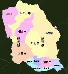
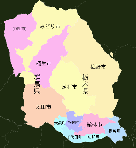
日本語: 狭義の両毛の範囲を表す地図。「両毛広域都市圏総合整備推進協議会」の構成自治体。 |
| Date | |
| Source | 地理院タイル(白地図)を加工して作成 |
| Author | オリジナル: 国土地理院 / 加工: Kahusi |
| Other versions |
 |
| SVG development | This vector image was created with Inkscape. |
Licensing
[edit]

|
This work is licensed under the Government of Japan Standard Terms of Use (Ver.2.0). The Terms of Use are compatible with the Creative Commons Attribution License 4.0 International. For the terms of use of this work, see this license page.
|
This file is licensed under the Creative Commons Attribution 4.0 International license.
Attribution: 国土地理院 (Geospatial Information Authority of Japan)
- You are free:
- to share – to copy, distribute and transmit the work
- to remix – to adapt the work
- Under the following conditions:
- attribution – You must give appropriate credit, provide a link to the license, and indicate if changes were made. You may do so in any reasonable manner, but not in any way that suggests the licensor endorses you or your use.
File history
Click on a date/time to view the file as it appeared at that time.
| Date/Time | Thumbnail | Dimensions | User | Comment | |
|---|---|---|---|---|---|
| current | 07:36, 25 October 2018 | | 3,072 × 3,328 (724 KB) | Kahusi (talk | contribs) | User created page with UploadWizard |
You cannot overwrite this file.
File usage on Commons
The following 2 pages use this file:
File usage on other wikis
The following other wikis use this file: