File:Range map-Senecio squalidus-Europe.svg
Jump to navigation
Jump to search

Size of this PNG preview of this SVG file: 680 × 520 pixels. Other resolutions: 314 × 240 pixels | 628 × 480 pixels | 1,004 × 768 pixels | 1,280 × 979 pixels | 2,560 × 1,958 pixels.
Original file (SVG file, nominally 680 × 520 pixels, file size: 521 KB)
Captions
Captions
Add a one-line explanation of what this file represents
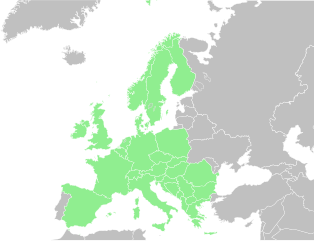
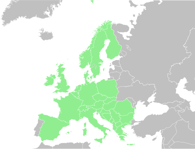
| Description | Range of Senecio squalidus in Europe. [1] | ||||||||
| Date | |||||||||
| Source |
based on Image:Blank map of Europe.svg by by several people
This W3C-unspecified vector image was created with Inkscape . W3C-validity not checked. |
||||||||
| Author | carol 06:11, 15 February 2008 (UTC) | ||||||||
| Permission (Reusing this file) |
|

File history
Click on a date/time to view the file as it appeared at that time.
| Date/Time | Thumbnail | Dimensions | User | Comment | |
|---|---|---|---|---|---|
| current | 06:11, 15 February 2008 | | 680 × 520 (521 KB) | CarolSpears (talk | contribs) | {{Information |Description=Range of ''Senecio squalidus'' in Europe[http://data.gbif.org/occurrences/searchCountries.htm?c&U+0050B;0&U+0050D;.s=20&c&U+0050B;0&U+0050D;.p=0&c&c&U+0050B;0&U+0050D;.o=13749824] |Source=based on [[:Image:Blank map of Europe.sv |
You cannot overwrite this file.
File usage on Commons
The following page uses this file:
File usage on other wikis
The following other wikis use this file:
- Usage on en.wikipedia.org
- Usage on fr.wikipedia.org