File:Rangarvallasysla.png
Jump to navigation
Jump to search
No higher resolution available.
Rangarvallasysla.png (501 × 375 pixels, file size: 41 KB, MIME type: image/png)
Captions
Captions
Add a one-line explanation of what this file represents
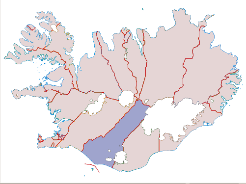
A map of the county Rangárvallasýsla in Iceland. Based on a map from the National Land Survey of Iceland. No copyright protedtion on the original map.
"Á þessari síðu eru sett fram nokkur kort sem heimilt er að nota í ýmsum tilgangi, án sérstaks leyfis frá stofnuninni. Fleiri kort munu bætast við á næstunni. Smelltu á kortið og þú færð upp stærri mynd.
| I, the copyright holder of this work, release this work into the public domain. This applies worldwide. In some countries this may not be legally possible; if so: I grant anyone the right to use this work for any purpose, without any conditions, unless such conditions are required by law. |
File history
Click on a date/time to view the file as it appeared at that time.
| Date/Time | Thumbnail | Dimensions | User | Comment | |
|---|---|---|---|---|---|
| current | 09:21, 22 February 2008 | | 501 × 375 (41 KB) | Jóna Þórunn (talk | contribs) | {{Information |Description=Map of Rangárvallasýsla, Iceland. |Source=own |Date=February 22, 2008. |Author=Jóna Þórunn Ragnarsdóttir |Permission=PD |other_versions= }} Category:Locator maps of counties of Iceland |
| 23:53, 7 April 2006 |  | 501 × 373 (42 KB) | Jóna Þórunn (talk | contribs) | A map of the county Rangárvallasýsla in Iceland. Based on a [http://www.lmi.is/landmaelingar.nsf/pages/vefkort.html map] from the National Land Survey of Iceland. No copyright protedtion on the original map. "''Á þessari síðu eru sett fram nokkur k |
You cannot overwrite this file.
File usage on Commons
The following page uses this file:
File usage on other wikis
The following other wikis use this file:
- Usage on fr.wikipedia.org
- Usage on is.wikipedia.org
- Usage on is.wikibooks.org
- Usage on ko.wikipedia.org
- Usage on pl.wikipedia.org
- Usage on www.wikidata.org