File:Randstad Population Bubbles (nl).svg
Jump to navigation
Jump to search

Size of this PNG preview of this SVG file: 651 × 599 pixels. Other resolutions: 261 × 240 pixels | 521 × 480 pixels | 834 × 768 pixels | 1,112 × 1,024 pixels | 2,225 × 2,048 pixels | 2,000 × 1,841 pixels.
Original file (SVG file, nominally 2,000 × 1,841 pixels, file size: 475 KB)
Captions
Captions
Add a one-line explanation of what this file represents
Summary
[edit].svg&action=edit§ion=1)
| Description |
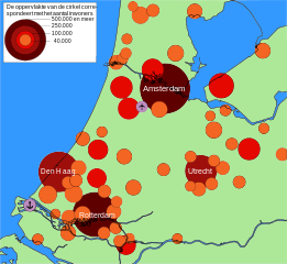
English: Map of towns and cities with more than 30.000 inhabitants in the central western Netherlands. The conurbation in this part of the country is known as the Randstad. The area (not diameter) of the circles correspond to the size of the population.
Number of inhabitants 500,000 and more
250,000 - 500,000
100,000 - 250,000
40,000 - 100,000
Map made with Inkscape. |
| Date | (UTC) |
| Source |
This file was derived from: Randstad Population Bubbles.svg: |
| Author |
|
| This is a retouched picture, which means that it has been digitally altered from its original version. The original can be viewed here: Randstad Population Bubbles.svg:
|
Licensing
[edit].svg&action=edit§ion=2)
I, the copyright holder of this work, hereby publish it under the following licenses:
This file is licensed under the Creative Commons Attribution-Share Alike 3.0 Unported license.
- You are free:
- to share – to copy, distribute and transmit the work
- to remix – to adapt the work
- Under the following conditions:
- attribution – You must give appropriate credit, provide a link to the license, and indicate if changes were made. You may do so in any reasonable manner, but not in any way that suggests the licensor endorses you or your use.
- share alike – If you remix, transform, or build upon the material, you must distribute your contributions under the same or compatible license as the original.

|
Permission is granted to copy, distribute and/or modify this document under the terms of the GNU Free Documentation License, Version 1.2 or any later version published by the Free Software Foundation; with no Invariant Sections, no Front-Cover Texts, and no Back-Cover Texts. A copy of the license is included in the section entitled GNU Free Documentation License. |
You may select the license of your choice.
Original upload log
[edit].svg&action=edit§ion=3)
This image is a derivative work of the following images:
- File:Randstad_Population_Bubbles.svg licensed with Cc-by-sa-3.0, GFDL
- 2010-06-14T13:53:09Z Junuxx 2000x1841 (492883 Bytes) Improved legend and color scheme
- 2010-06-14T13:27:13Z Junuxx 2000x1841 (491623 Bytes) Added land/water color.
- 2010-06-12T02:57:06Z Junuxx 2000x1841 (393897 Bytes) Fixed a problem with unsupported flowRoot namespace. Also changed nominal size.
- 2010-06-12T02:02:27Z Junuxx 744x1052 (570256 Bytes) One more time.
- 2010-06-12T01:57:34Z Junuxx 744x1052 (570248 Bytes) Fixed image, hope it will actually show now.
- 2010-06-12T01:49:43Z Junuxx 744x1052 (155638 Bytes) {{Information |Description={{en|1=Map of towns and cities with more than 40.000 inhabitants in the central western Netherlands. The conurbation in this part of the country is known as the [[:en:Randstad|Randstad]]. The area (
Uploaded with derivativeFX
File history
Click on a date/time to view the file as it appeared at that time.
| Date/Time | Thumbnail | Dimensions | User | Comment | |
|---|---|---|---|---|---|
| current | 16:07, 12 July 2013 | | 2,000 × 1,841 (475 KB) | Richardw (talk | contribs) | bijschrift: 500.000 of meer |
| 11:23, 8 May 2012 |  | 2,000 × 1,841 (475 KB) | Karlfk (talk | contribs) | == {{int:filedesc}} == {{Information |Description={{en|1=Map of towns and cities with more than 30.000 inhabitants in the central western Netherlands. The conurbation in this part of the country is known as the Randstad. The area (not ... |
You cannot overwrite this file.
File usage on Commons
There are no pages that use this file.
File usage on other wikis
The following other wikis use this file:
- Usage on de.wikivoyage.org
- Usage on nl.wikipedia.org
- Usage on no.wikipedia.org
.svg&oldid=491404811)