File:Rand McNally & Co's new commercial map of Europe (14960195732).jpg
Jump to navigation
Jump to search

Size of this preview: 772 × 600 pixels. Other resolutions: 309 × 240 pixels | 618 × 480 pixels | 989 × 768 pixels | 1,280 × 994 pixels | 2,560 × 1,989 pixels | 15,377 × 11,946 pixels.
Original file (15,377 × 11,946 pixels, file size: 31.87 MB, MIME type: image/jpeg)
Captions
Captions
Add a one-line explanation of what this file represents
Summary
[edit]| Description |
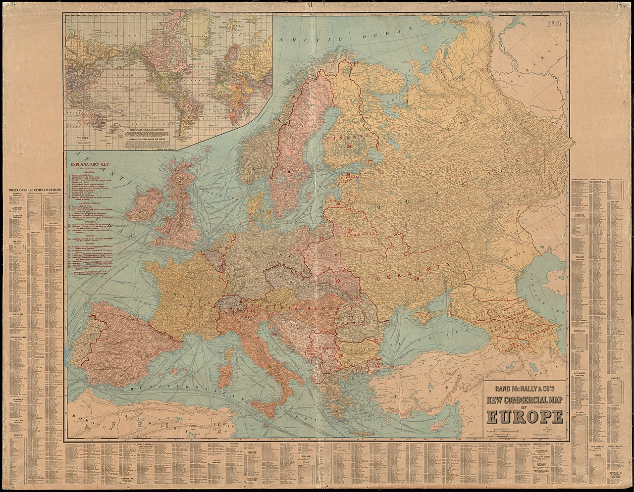
Zoom into this map at maps.bpl.org. Author: Rand McNally and Company Publisher: Rand McNally and Company Date: 1922 Location: Europe Dimensions: 98 x 115 cm Scale: 1:4,561,920 Call Number: G5700 1922 .R36 |
| Date | |
| Source | Rand McNally & Co's new commercial map of Europe |
| Author | Norman B. Leventhal Map Center |
| Other versions |
_(detail_of_Schleswig).jpg)
_(detail_of_Heligoland).jpg)
_(detail_of_Moresnet,_Eupen_%26_Malmedy).jpg)
_(detail_of_the_Saar_basin).jpg)
_(detail_of_Alsace-Lorraine).jpg)
_(detail_of_Leobsch%C3%BCtz).jpg)
_(detail_of_Upper_Silesia).jpg)
_(detail_of_German_cession_to_Poland).jpg)
_(detail_of_Danzig).jpg)
_(detail_of_East_Prussia).jpg)
_(detail_of_Memel).jpg)
_(detail_of_Austrian_cession_to_Italy).jpg)
_(detail_of_Klagenfurt).jpg)
_(detail_of_area_disputed_by_Serb-Croat-Slovene_State_%26_Italy).jpg)
_(detail_of_Bukowina).jpg)
_(detail_of_Galicia).jpg)
_(detail_of_Bulgarian_cession_to_Serbia).jpg)
_(detail_of_West_Thrace).jpg)
_(detail_of_East_Thrace).jpg)
_(detail_of_South_Dobruja).jpg)
_(detail_of_Finland).jpg)
_(detail_of_Esthonia).jpg)
_(detail_of_Latvia).jpg)
_(detail_of_Lithuania).jpg)
_(detail_of_Ukrainia).jpg)
_(detail_of_Daghestan).jpg)
_(detail_of_Georgia).jpg)
_(detail_of_Azerbaijan_%26_Armenia).jpg)
_(inset_map).jpg)
.jpg&action=edit§ion=1)
_(detail_of_Transylvania).jpg)
Licensing
[edit].jpg&action=edit§ion=2)
This file is licensed under the Creative Commons Attribution 2.0 Generic license.
- You are free:
- to share – to copy, distribute and transmit the work
- to remix – to adapt the work
- Under the following conditions:
- attribution – You must give appropriate credit, provide a link to the license, and indicate if changes were made. You may do so in any reasonable manner, but not in any way that suggests the licensor endorses you or your use.
| This image was originally posted to Flickr by Norman B. Leventhal Map Center at the BPL at https://flickr.com/photos/24528911@N05/14960195732. It was reviewed on 23 October 2017 by FlickreviewR and was confirmed to be licensed under the terms of the cc-by-2.0. |
File history
Click on a date/time to view the file as it appeared at that time.
| Date/Time | Thumbnail | Dimensions | User | Comment | |
|---|---|---|---|---|---|
| current | 21:51, 31 August 2022 | | 15,377 × 11,946 (31.87 MB) | GPinkerton (talk | contribs) | Higher resolution from website (https://collections.leventhalmap.org/search/commonwealth:4m90fn75j) |
| 14:31, 23 October 2017 |  | 2,000 × 1,554 (3.57 MB) | Ser Amantio di Nicolao (talk | contribs) | Transferred from Flickr via Flickr2Commons |
You cannot overwrite this file.
File usage on Commons
The following 30 pages use this file:
- File:Rand McNally & Co's new commercial map of Europe (14960195732) (detail of Alsace-Lorraine).jpg
- File:Rand McNally & Co's new commercial map of Europe (14960195732) (detail of Austrian cession to Italy).jpg
- File:Rand McNally & Co's new commercial map of Europe (14960195732) (detail of Azerbaijan & Armenia).jpg
- File:Rand McNally & Co's new commercial map of Europe (14960195732) (detail of Bukowina).jpg
- File:Rand McNally & Co's new commercial map of Europe (14960195732) (detail of Bulgarian cession to Serbia).jpg
- File:Rand McNally & Co's new commercial map of Europe (14960195732) (detail of Daghestan).jpg
- File:Rand McNally & Co's new commercial map of Europe (14960195732) (detail of Danzig).jpg
- File:Rand McNally & Co's new commercial map of Europe (14960195732) (detail of East Prussia).jpg
- File:Rand McNally & Co's new commercial map of Europe (14960195732) (detail of East Thrace).jpg
- File:Rand McNally & Co's new commercial map of Europe (14960195732) (detail of Esthonia).jpg
- File:Rand McNally & Co's new commercial map of Europe (14960195732) (detail of Finland).jpg
- File:Rand McNally & Co's new commercial map of Europe (14960195732) (detail of Galicia).jpg
- File:Rand McNally & Co's new commercial map of Europe (14960195732) (detail of Georgia).jpg
- File:Rand McNally & Co's new commercial map of Europe (14960195732) (detail of German cession to Poland).jpg
- File:Rand McNally & Co's new commercial map of Europe (14960195732) (detail of Heligoland).jpg
- File:Rand McNally & Co's new commercial map of Europe (14960195732) (detail of Klagenfurt).jpg
- File:Rand McNally & Co's new commercial map of Europe (14960195732) (detail of Latvia).jpg
- File:Rand McNally & Co's new commercial map of Europe (14960195732) (detail of Leobschütz).jpg
- File:Rand McNally & Co's new commercial map of Europe (14960195732) (detail of Lithuania).jpg
- File:Rand McNally & Co's new commercial map of Europe (14960195732) (detail of Memel).jpg
- File:Rand McNally & Co's new commercial map of Europe (14960195732) (detail of Moresnet, Eupen & Malmedy).jpg
- File:Rand McNally & Co's new commercial map of Europe (14960195732) (detail of Schleswig).jpg
- File:Rand McNally & Co's new commercial map of Europe (14960195732) (detail of South Dobruja).jpg
- File:Rand McNally & Co's new commercial map of Europe (14960195732) (detail of Transylvania).jpg
- File:Rand McNally & Co's new commercial map of Europe (14960195732) (detail of Ukrainia).jpg
- File:Rand McNally & Co's new commercial map of Europe (14960195732) (detail of Upper Silesia).jpg
- File:Rand McNally & Co's new commercial map of Europe (14960195732) (detail of West Thrace).jpg
- File:Rand McNally & Co's new commercial map of Europe (14960195732) (detail of area disputed by Serb-Croat-Slovene State & Italy).jpg
- File:Rand McNally & Co's new commercial map of Europe (14960195732) (detail of the Saar basin).jpg
- File:Rand McNally & Co's new commercial map of Europe (14960195732) (inset map).jpg
.jpg&oldid=775163412)