File:Rammasun 2008 track.png
Jump to navigation
Jump to search

Size of this preview: 701 × 600 pixels. Other resolutions: 281 × 240 pixels | 561 × 480 pixels | 898 × 768 pixels | 1,197 × 1,024 pixels | 2,394 × 2,048 pixels | 2,700 × 2,310 pixels.
Original file (2,700 × 2,310 pixels, file size: 1.18 MB, MIME type: image/png)
Captions
Captions
Add a one-line explanation of what this file represents
Summary
| Description |
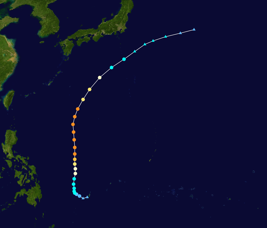
English: Track map of Typhoon Rammasun of the 2008 Pacific typhoon season. The points show the location of the storm at 6-hour intervals. The colour represents the storm's maximum sustained wind speeds as classified in the (see below), and the shape of the data points represent the nature of the storm, according to the legend below. Tropical depression (≤38 mph, ≤62 km/h)
Tropical storm (39–73 mph, 63–118 km/h)
Category 1 (74–95 mph, 119–153 km/h)
Category 2 (96–110 mph, 154–177 km/h)
Category 3 (111–129 mph, 178–208 km/h)
Category 4 (130–156 mph, 209–251 km/h)
Category 5 (≥157 mph, ≥252 km/h)
Unknown
Storm type |
||
| Date | 2008-05-06–2008-05-14 | ||
| Source | Created by Ramisses using Wikipedia:WikiProject Tropical cyclones/Tracks. The background image is from NASA. Tracking data is from the Joint Typhoon Warning Center[1]. | ||
| Author | Ramisses | ||
| Source code | Track map data table, if present below, is in HURDAT2 or ATCF format. See format details in [2] and [3], respectively.
|
Licensing
[edit]| This work has been released into the public domain by its author, Ramisses. This applies worldwide. In some countries this may not be legally possible; if so: Ramisses grants anyone the right to use this work for any purpose, without any conditions, unless such conditions are required by law. |
File history
Click on a date/time to view the file as it appeared at that time.
| Date/Time | Thumbnail | Dimensions | User | Comment | |
|---|---|---|---|---|---|
| current | 22:19, 18 July 2020 | | 2,700 × 2,310 (1.18 MB) | Supportstorm (talk | contribs) | JTWC/JMA data |
| 03:11, 2 January 2020 |  | 2,700 × 2,298 (837 KB) | Nino Marakot (talk | contribs) | IBTrACS version + OPC wind data | |
| 20:59, 30 June 2016 |  | 1,024 × 787 (315 KB) | Cyclonebiskit (talk | contribs) | Reverted to version as of 21:40, 12 July 2015 (UTC) | |
| 12:38, 22 June 2016 |  | 1,024 × 787 (360 KB) | セリヌンティクス (talk | contribs) | After a review of the criteria for a typhoon of Category 5,It was meet the criteria for Category 5. | |
| 21:40, 12 July 2015 |  | 1,024 × 787 (315 KB) | Supportstorm (talk | contribs) | Reverted to version as of 12:50, 16 April 2009 | |
| 12:04, 12 July 2015 |  | 560 × 614 (72 KB) | セリヌンティクス (talk | contribs) | category5 super tyhoon. | |
| 12:50, 16 April 2009 |  | 1,024 × 787 (315 KB) | Potapych (talk | contribs) | Best track update | |
| 23:44, 29 May 2008 |  | 1,024 × 760 (248 KB) | Nilfanion (talk | contribs) | WPTC track | |
| 01:51, 22 May 2008 |  | 1,024 × 636 (29 KB) | Ramisses (talk | contribs) | {{Information |Description= |Source= |Date= |Author= |Permission= |other_versions= }} | |
| 18:04, 13 May 2008 |  | 1,024 × 636 (24 KB) | Ramisses (talk | contribs) | == Summary == Typhoon Rammasun (2008) track map. Tracking data from [http://www.webcitation.org/5Xm2RmE3d JTWC] '''Alert''': This track map should be replaced by a WikiProject Tropical cyclones track map when is available. {{Information |Description=Typ |
You cannot overwrite this file.
File usage on Commons
There are no pages that use this file.
File usage on other wikis
The following other wikis use this file:
- Usage on de.wikipedia.org
- Usage on en.wikipedia.org
- Usage on ja.wikipedia.org
- Usage on ko.wikipedia.org
- Usage on pt.wikipedia.org
- Usage on th.wikipedia.org
- Usage on vi.wikipedia.org
- Usage on zh.wikipedia.org