File:Rainfall of Matthew in the Caribbean.jpg
Jump to navigation
Jump to search
Size of this preview: 800 × 450 pixels. Other resolutions: 320 × 180 pixels | 640 × 360 pixels | 1,280 × 720 pixels.
Original file (1,280 × 720 pixels, file size: 222 KB, MIME type: image/jpeg)
Captions
Captions
Add a one-line explanation of what this file represents
Summary
[edit]
| Description |
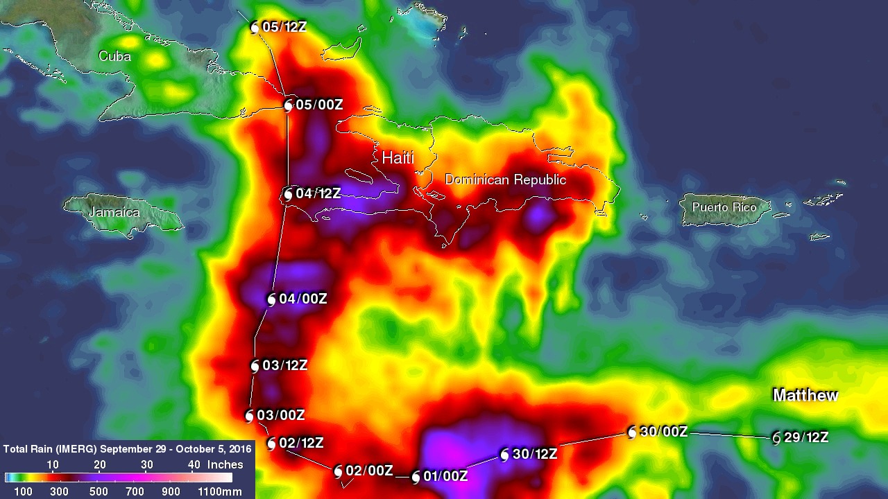
English: This image shows IMERG rainfall estimates for the period September 29 to October 5, 2016 for the northeastern Caribbean in association with the passage of Hurricane Matthew, which is indicated by the white line and corresponding storm symbols. Beginning at 00 UTC on the Sept. 30, rainfall totals associated with Matthew are in excess of 10 inches all along its track (shown in red), reaching upwards of 25 inches (shown in pink) when the storm was intensifying on Sept. 30. Over land, IMERGE shows wide areas of between 15 to 20 inches of rain (dark red and purple areas, respectively) all along the southern coasts of Haiti and the Dominican Republic on the island of Hispaniola. |
| Date | |
| Source | https://www.nasa.gov/feature/goddard/2016/matthew-atlantic-ocean |
| Author | NASA |
Licensing
[edit]
| This file is in the public domain in the United States because it was solely created by NASA. NASA copyright policy states that "NASA material is not protected by copyright unless noted". (See Template:PD-USGov, NASA copyright policy page or JPL Image Use Policy.) | ||
 |
Warnings:
|
File history
Click on a date/time to view the file as it appeared at that time.
| Date/Time | Thumbnail | Dimensions | User | Comment | |
|---|---|---|---|---|---|
| current | 06:14, 28 February 2018 | | 1,280 × 720 (222 KB) | A1Cafel (talk | contribs) | User created page with UploadWizard |
You cannot overwrite this file.
File usage on Commons
There are no pages that use this file.
File usage on other wikis
The following other wikis use this file:
- Usage on fr.wikipedia.org