File:Railway size world map.PNG
Jump to navigation
Jump to search
Size of this preview: 800 × 373 pixels. Other resolutions: 320 × 149 pixels | 640 × 299 pixels | 1,350 × 630 pixels.
Original file (1,350 × 630 pixels, file size: 40 KB, MIME type: image/png)
Captions
Captions
Add a one-line explanation of what this file represents

Summary
[edit]
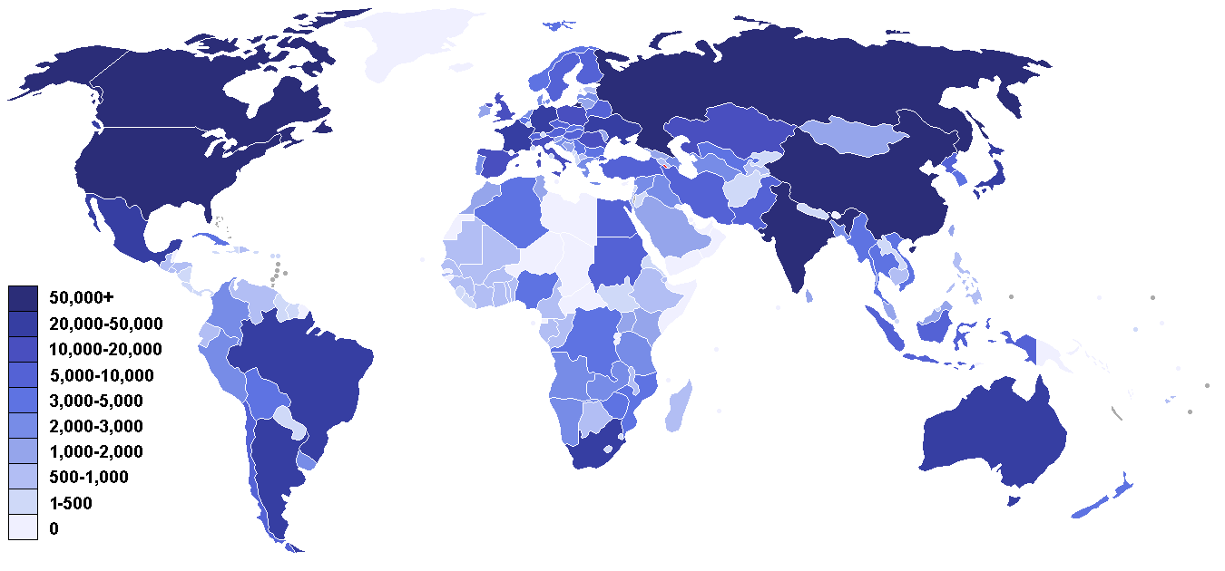
Railway size in km, based on CIA world factbook archive copy at the Wayback Machine, accessed March 2006, updated in July 2007 using en:List of countries by rail transport network size
Licensing
[edit]

|
Permission is granted to copy, distribute and/or modify this document under the terms of the GNU Free Documentation License, Version 1.2 or any later version published by the Free Software Foundation; with no Invariant Sections, no Front-Cover Texts, and no Back-Cover Texts. A copy of the license is included in the section entitled GNU Free Documentation License. |
| This file is licensed under the Creative Commons Attribution-Share Alike 3.0 Unported license. | ||
| ||
| This licensing tag was added to this file as part of the GFDL licensing update. |
File history
Click on a date/time to view the file as it appeared at that time.
| Date/Time | Thumbnail | Dimensions | User | Comment | |
|---|---|---|---|---|---|
| current | 14:12, 12 February 2018 | | 1,350 × 630 (40 KB) | Maphobbyist (talk | contribs) | Added South Sudan, which has 248 km of railways. |
| 18:27, 31 July 2007 |  | 1,350 × 630 (35 KB) | Jklamo (talk | contribs) | small update | |
| 18:11, 31 July 2007 |  | 1,350 × 630 (35 KB) | Jklamo (talk | contribs) | ||
| 11:07, 27 November 2006 |  | 1,350 × 630 (36 KB) | Roke~commonswiki (talk | contribs) | ||
| 05:35, 14 July 2006 |  | 1,350 × 630 (36 KB) | Roke~commonswiki (talk | contribs) | one color version | |
| 15:12, 31 March 2006 |  | 1,350 × 630 (51 KB) | Roke~commonswiki (talk | contribs) | minor fix of key | |
| 15:10, 31 March 2006 |  | 1,350 × 630 (51 KB) | Roke~commonswiki (talk | contribs) | Railway size in km, based on [http://www.cia.gov/cia/publications/factbook/rankorder/2121rank.html CIA world factbook], accessed March 2006 Category: Railways |
You cannot overwrite this file.
File usage on Commons
The following 6 pages use this file:
- User:Chumwa/OgreBot/Potential transport maps/2018 February 10-18
- User:Chumwa/OgreBot/Public transport information/2018 February 10-18
- User:Chumwa/OgreBot/Transport Maps/2018 February 10-18
- User:Chumwa/OgreBot/Travel and communication maps/2018 February 10-18
- User:Frettiebot/Galleries/Jklamo/2007/7
- User:Jklamo/Gallery