File:Railway lines in Borovnica area-map.png

Original file (757 × 702 pixels, file size: 135 KB, MIME type: image/png)
Captions
Captions
Summary
[edit]| DescriptionRailway lines in Borovnica area-map.png |
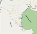
English: Temporary "solution" until SVG rendering issues for File:Railway lines in Borovnica area-map.svg are resolved.
A map of the current and former railway routes in Borovnica area and location of the Borovnica railway viadukt (in German also known as Franzdorfer Viadukt) Slovenščina: Začasna "rešitev" dokler se ne razrešijo problemi glede pretvarjanja slike File:Railway lines in Borovnica area-map.svg iz zapisa SVG Zemljevid sedanje in nekdanjih železniških prog na območju Borovniške doline ter lega nekdanjega borovniškega viadukta. |
| Date | |
| Source | Based on a map from OpenStreetMap (http://www.openstreetmap.org/?lat=45.9368&lon=14.36&zoom=13&layers=B000FTFT) |
| Author | Ajznponar |
| Permission (Reusing this file) |
License: CC-BY-SA 2.0 (as applies for maps from OpenStreetMap) |
| Other versions | File:Railway lines in Borovnica area-map.svg |
Licensing
[edit]- You are free:
- to share – to copy, distribute and transmit the work
- to remix – to adapt the work
- Under the following conditions:
- attribution – You must give appropriate credit, provide a link to the license, and indicate if changes were made. You may do so in any reasonable manner, but not in any way that suggests the licensor endorses you or your use.
- share alike – If you remix, transform, or build upon the material, you must distribute your contributions under the same or compatible license as the original.
File history
Click on a date/time to view the file as it appeared at that time.
| Date/Time | Thumbnail | Dimensions | User | Comment | |
|---|---|---|---|---|---|
| current | 19:39, 2 November 2009 |  | 757 × 702 (135 KB) | Ajznponar (talk | contribs) | {{Information |Description={{en|1=Temporary "solution" until SVG rendering issues for File:Railway lines in Borovnica area-map.svg are resolved. A map of the current and former railway routes in Borovnica area and location of the Borovnica railway v |
You cannot overwrite this file.
File usage on Commons
There are no pages that use this file.
File usage on other wikis
The following other wikis use this file:
- Usage on de.wikipedia.org
- Usage on sl.wikipedia.org