File:Railroad map of Pennsylvania Company showing the Pennsylvania Railroad, Pittsburgh, Fort Wayne and Chicago Railway, Pittsburgh, Cincinnati and St. Louis Railway, and their connecting eastern and LOC 98688764.jpg
Jump to navigation
Jump to search

Size of this preview: 800 × 354 pixels. Other resolutions: 320 × 142 pixels | 640 × 283 pixels | 1,024 × 454 pixels | 1,280 × 567 pixels | 2,560 × 1,134 pixels | 23,406 × 10,366 pixels.
Original file (23,406 × 10,366 pixels, file size: 39.42 MB, MIME type: image/jpeg)
Captions
Captions
Add a one-line explanation of what this file represents
Summary
[edit]| Warning | The original file is very high-resolution. It might not load properly or could cause your browser to freeze when opened at full size. |
|---|
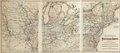
| Description |
English: Map of the middle Atlantic and midwestern states showing drainage, cities and towns, township and county boundaries, and the railroad network with names of lines and mileage between stations. |
||
| Title | Railroad map of Pennsylvania Company showing the Pennsylvania Railroad, Pittsburgh, Fort Wayne and Chicago Railway, Pittsburgh, Cincinnati and St. Louis Railway, and their connecting eastern and western lines. | ||
| Shelf ID | G3701.P3 1871 .G15 | ||
| Date | |||
| Source | https://www.loc.gov/item/98688764/ | ||
| Author | G.W. & C. Colton & Co.; Pennsylvania Railroad | ||
| Permission (Reusing this file) |
|
||
| Other versions |
|
||
| Location | United States | ||
| Part of | American Memory · Catalog · Railroad Maps, 1828-1900 · Geography And Map Division · Transportation And Communication | ||
| Subject | Pittsburgh, Fort Wayne, And Chicago Railway Company · Pennsylvania Railroad · Railroads · United States · Maps · Pittsburgh, Cincinnati And St. Louis Railway |

Licensing
[edit]
|
This is a faithful photographic reproduction of a two-dimensional, public domain work of art. The work of art itself is in the public domain for the following reason:
The official position taken by the Wikimedia Foundation is that "faithful reproductions of two-dimensional public domain works of art are public domain".
This photographic reproduction is therefore also considered to be in the public domain in the United States. In other jurisdictions, re-use of this content may be restricted; see Reuse of PD-Art photographs for details. | ||||
File history
Click on a date/time to view the file as it appeared at that time.
| Date/Time | Thumbnail | Dimensions | User | Comment | |
|---|---|---|---|---|---|
| current | 10:51, 3 June 2018 | | 23,406 × 10,366 (39.42 MB) | Fæ (talk | contribs) | LOC Maps https://www.loc.gov/item/98688764/ #3345 |
You cannot overwrite this file.
File usage on Commons
The following page uses this file: