File:Rail Tracks map Meitetsu Sako Station.svg
Jump to navigation
Jump to search

Size of this PNG preview of this SVG file: 660 × 210 pixels. Other resolutions: 320 × 102 pixels | 640 × 204 pixels | 1,024 × 326 pixels | 1,280 × 407 pixels | 2,560 × 815 pixels.
Original file (SVG file, nominally 660 × 210 pixels, file size: 27 KB)
Captions
Captions
Add a one-line explanation of what this file represents
Summary
[edit]
| Description |
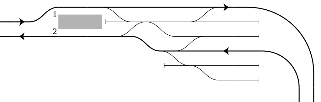
English: Rail tracks map of Nagoya Railroad Sakō Station in Nishi-ku, Nagoya Aichi Pref., Japan.
Reference material: DENKISHA KENKYUKAI, "THE RAILWAY PICTORIAL" Vol.816, Extra edition - "名古屋鉄道(Nagoya Railroad)" insert page at end, 2009-03 日本語: 名古屋市西区にある名古屋鉄道 栄生(さこう)駅 構内配線略図
参考文献:電気車研究会、『鉄道ピクトリアル』通巻第816号 2009年3月 臨時増刊号 「特集 - 名古屋鉄道」、巻末折込「名古屋鉄道 配線略図」 凡例は駅配線図テンプレートを参照 Français : Plan de voies |
||
| Date | |||
| Source | Tawashi2006 created from icons in Category:Rail_tracks_map_template. | ||
| Author | Tawashi2006 with pdv2svg | ||
| Permission (Reusing this file) |
|
File history
Click on a date/time to view the file as it appeared at that time.
| Date/Time | Thumbnail | Dimensions | User | Comment | |
|---|---|---|---|---|---|
| current | 15:17, 27 January 2022 | 660 × 210 (27 KB) | ButuCC (talk | contribs) | modify | |
| 15:53, 13 June 2009 | 660 × 210 (10 KB) | Tawashi2006 (talk | contribs) | == Summary == {{Information |Description = {{en|1=Rail tracks map of Nagoya Railroad '''Sakō Station''' in Nishi-ku, Nagoya Aichi Pref., Japan. |
You cannot overwrite this file.
File usage on Commons
The following page uses this file:
File usage on other wikis
The following other wikis use this file: