File:Radziejowice (gmina) location map.png
Jump to navigation
Jump to search

Size of this preview: 800 × 482 pixels. Other resolutions: 320 × 193 pixels | 640 × 386 pixels | 833 × 502 pixels.
Original file (833 × 502 pixels, file size: 80 KB, MIME type: image/png)
Captions
Captions
Add a one-line explanation of what this file represents
| Description |
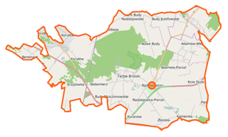
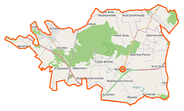
Polski: Mapa gminy Radziejowice, Polska
English: Map of Gmina Radziejowice, Poland |
|||||||||
| Date | ||||||||||
| Source | You may find a page on the OpenStreetMap wiki page for Radziejowice (gmina) | |||||||||
| Creator |
OpenStreetMap contributors OpenStreetMap contributors |
|||||||||
| Permission (Reusing this file) |
OpenStreetMap data is available under the Open Database License (details). Map tiles are licensed under the Creative Commons Attribution-ShareAlike 2.0 license (CC-BY-SA 2.0).
This file is licensed under the Creative Commons Attribution-Share Alike 2.0 Generic license.
|
|||||||||
| Geotemporal data | ||||||||||
| Bounding box |
|
|||||||||
| Georeferencing | If inappropriate please set warp_status = skip to hide. | |||||||||
File history
Click on a date/time to view the file as it appeared at that time.
| Date/Time | Thumbnail | Dimensions | User | Comment | |
|---|---|---|---|---|---|
| current | 06:16, 20 October 2014 | | 833 × 502 (80 KB) | VanWiel (talk | contribs) | {{OpenStreetMap | name = Radziejowice (gmina) | location = Radziejowice (gmina) | description = {{pl|Mapa gminy Radziejowice, Polska}} {{en|Map of Gmina Radziejowice, Poland}} | top = 52.0573 | left... |
You cannot overwrite this file.
File usage on Commons
There are no pages that use this file.
File usage on other wikis
The following other wikis use this file:
- Usage on fr.wikipedia.org
- Usage on pl.wikipedia.org
- Rezerwat przyrody Dąbrowa Radziejowska
- Radziejowice (gmina)
- Radziejowice
- Benenard
- Budy Józefowskie
- Budy Mszczonowskie
- Chroboty
- Krze Duże
- Kuklówka Radziejowicka
- Kuklówka Zarzeczna
- Kuranów
- Pieńki-Towarzystwo
- Radziejowice-Parcel
- Stare Budy Radziejowskie
- Tartak Brzózki
- Korytów (województwo mazowieckie)
- Krzyżówka (województwo mazowieckie)
- Słabomierz (województwo mazowieckie)
- Zboiska (województwo mazowieckie)
- Nowe Budy (powiat żyrardowski)
- Podlasie (powiat żyrardowski)
- Zazdrość (powiat żyrardowski)
- Kamionka (gmina Radziejowice)
- Adamów-Wieś
- Adamów-Parcel
- Dąb Chełmońskiego
- Korytów A
- Korytów (stacja kolejowa)
- Zespół pałacowo-parkowy w Radziejowicach
- Parafia św. Kazimierza Królewicza w Radziejowicach
- Moduł:Mapa/dane/Radziejowice (gmina)
- Kościół św. Kazimierza Królewicza w Radziejowicach
- Parafia Matki Bożej Częstochowskiej w Kuklówce
- Krze Małe
- Usage on pl.wikibooks.org
_location_map.png&oldid=519994663)