File:Radar-accumulations eng.png
Jump to navigation
Jump to search
Size of this preview: 769 × 600 pixels. Other resolutions: 308 × 240 pixels | 616 × 480 pixels.
Original file (800 × 624 pixels, file size: 159 KB, MIME type: image/png)
Captions
Captions
Add a one-line explanation of what this file represents
Summary
[edit]
| Description |
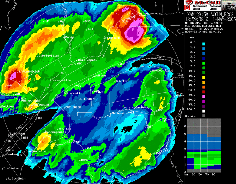
Français : Accumulations de 24 heures estimées à partir du radar de Val d'Irène dans l'est du Québec, Canada. Remarquez les cônes sans données vers l'est et le sud-ouest qui sont dus à des montagnes bloquant le faisceau radar. On voit également un zone plus intense en forme de beiget à la limite du radar qui est due à un rehaussement des retours par la bande brillante.
English: 24 hours accumulations deduced by Val d'Irene radar in Eastern Quebec (Canada). Some bright band effect visible with the stronger values at the outer right area. |
| Date | 2005-05-01, 1259 UTC |
| Source |
English: Meteorological Service of Canada (Environment Canada). Redistribution allowed if source mentionned |
| Author |
Français : Ce radar est opéré par Environnement Canada. La sortie radar est produite par le logiciel développé par l'Observatoire radar J.S. Marshall de l'Université McGill en collaboration avec EC. |
Licensing
[edit]

|
The copyright holder of this work allows anyone to use it for any purpose including unrestricted redistribution, commercial use, and modification.
Usage notes:
|
File history
Click on a date/time to view the file as it appeared at that time.
| Date/Time | Thumbnail | Dimensions | User | Comment | |
|---|---|---|---|---|---|
| current | 14:49, 8 May 2006 | | 800 × 624 (159 KB) | Pierre cb (talk | contribs) | 24 hours accumulations deduced by Val d'Irene radar in Eastern Quebec (Canada). Some bright band effect visible with the stronger vlaues at the outer right area. Source: Meteorological Service of Canada (Environment Canada). Redistribution allowed if sou |
You cannot overwrite this file.
File usage on Commons
There are no pages that use this file.
File usage on other wikis
The following other wikis use this file:
- Usage on en.wikipedia.org
- Usage on es.wikipedia.org
- Usage on fr.wikipedia.org
- Usage on id.wikipedia.org
- Usage on ms.wikipedia.org
- Usage on pt.wikipedia.org