File:Raabego Natolin.jpg
Jump to navigation
Jump to search

Size of this preview: 800 × 600 pixels. Other resolutions: 320 × 240 pixels | 640 × 480 pixels | 1,024 × 768 pixels.
Original file (1,024 × 768 pixels, file size: 612 KB, MIME type: image/jpeg)
Captions
Captions
Add a one-line explanation of what this file represents
| Camera location | | View this and other nearby images on: OpenStreetMap |
|---|
| Description |
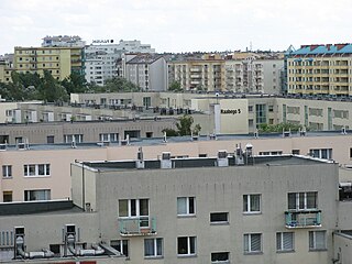
Polski: Bloki mieszkalne na ursynowskich osiedlach Natolin i Kabaty. Na pierwszym planie zabudowania ul. Raabego, w głębi budynki przy alei Komisji Edukacji Narodowej i ul. Wąwozowej. Zdjęcie wykonane z czwartego piętra bloku przy ul. Belgradzkiej. English: View over apartment blocks in Natolin in the direction of Kabaty |
||
| Date | originally uploaded on November 23rd, 2007 | ||
| Source | Warszawikia | ||
| Author | Kakarakak | ||
| Permission (Reusing this file) |
|
File history
Click on a date/time to view the file as it appeared at that time.
| Date/Time | Thumbnail | Dimensions | User | Comment | |
|---|---|---|---|---|---|
| current | 23:12, 17 December 2008 | | 1,024 × 768 (612 KB) | Botev (talk | contribs) | {{Location|52|08|27.63|N|21|03|35.71|E|heading:S}} {{Information |Description={{pl|Bloki mieszkalne na ursynowskich osiedlach Natolin i Kabaty. Na pierwszym planie zabudowania ul. Raabego, w głębi budynki przy alei Komisji Edukacji Narodowej i ul. Wąwo |
You cannot overwrite this file.
File usage on Commons
There are no pages that use this file.