File:RPPN Cara da Onça Paulo Robson de Souza (23).jpg
Original file (3,680 × 2,456 pixels, file size: 5.48 MB, MIME type: image/jpeg)
Captions
Captions
Summary
[edit].jpg&action=edit§ion=1)
| Description |
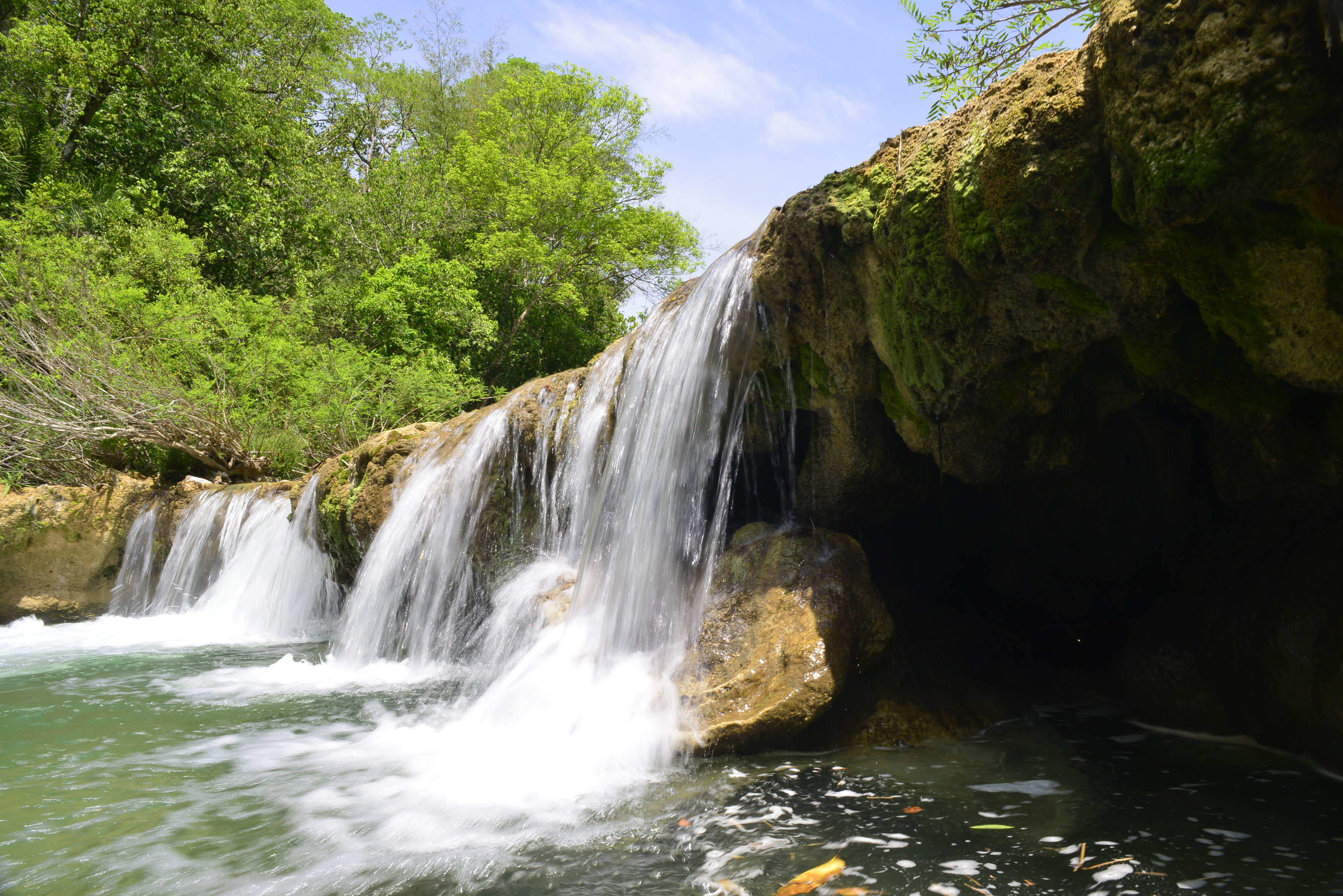
Português: Reserva Particular do Patrimônio Natural Cara da Onça de nível Estadual, localizado (a) em Bodoquena (MS)
Diferentemente de outras localidades, em que a força e o atrito das águas dos rios desgastam as rochas com o passar do tempo, na Serra da Bodoquena acontece o contrário: elas crescem pelas águas! Isto é causado pela constante deposição dos carbonatos dissolvidos na água em troncos, folhas, musgos, algas e nas próprias rochas, formando as tufas calcárias. Tal fenômeno faz os especialistas afirmarem que diversos rios da região (principalmente os dos municípios de Bonito e Bodoquena) são, a rigor, uma sucessão de represas naturais. Este “efeito represa” está bem evidenciado na foto: vê-se a base e a crista da barragem de tufas calcárias represando as águas que descem o rio Salobra. É provável que esta barragem esteja mais alta alguns centímetros, daqui a algumas décadas. Por isso que se diz que na Serra da Bodoquena “as cachoeiras crescem!” Referências Dr. Paulo Cesar Boggiani/USP, em comunicação pessoal (31.07.2020) BOGGIANI, P.C.; COIMBRA, A.M.; GESICKI, A.L. ; SIAL, A.N.; FERREIRA, V.P. ; RIBEIRO, F. B. ; FLEXOR, J. M. Tufas Calcárias da Serra da Bodoquena. São Paulo: SIGEP, 1999 <http://sigep.cprm.gov.br/sitio034/sitio034.htm> SCREMIN-DIAS, E.; HORA, R. C.; POTT, V. J. ; SOUZA, P. R.. Nos jardins submersos da Bodoquena : guia para identificação de plantas aquáticas de Bonito e região. 1. ed. Campo Grande: Editora UFMS, 1999. v. 1. 160p . <https://ecoa.org.br/wp-content/uploads/2016/12/Nos-Jardins-Submersos-da-Bodoquena.pdf> |
| Date | |
| Source | Own work |
| Author | Paulo Robson de Souza |
| Camera location | | View this and other nearby images on: OpenStreetMap |
|---|
.jpg¶ms=-20.737694_N_-056.737389_E_globe:Earth_type:camera__&language=en)
PELLIN, Angela; FERNANDES, Hamilton de Menezes; SSHEFFLER, Sando Marcelo (coord.). Reserva Particular do Patrimônio Natural Cara da Onça: plano de manejo. Imasul, 2010. Disponível em: <http://www.imasul.ms.gov.br/wp-content/uploads/2015/06/7-PlanodeManejoRPPNCaradaon%C3%A7a.pdf>
Licensing
[edit].jpg&action=edit§ion=2)
- You are free:
- to share – to copy, distribute and transmit the work
- to remix – to adapt the work
- Under the following conditions:
- attribution – You must give appropriate credit, provide a link to the license, and indicate if changes were made. You may do so in any reasonable manner, but not in any way that suggests the licensor endorses you or your use.
- share alike – If you remix, transform, or build upon the material, you must distribute your contributions under the same or compatible license as the original.
This image was uploaded as part of Wiki Loves Earth 2020.
|
 |
File history
Click on a date/time to view the file as it appeared at that time.
| Date/Time | Thumbnail | Dimensions | User | Comment | |
|---|---|---|---|---|---|
| current | 22:59, 31 July 2020 | | 3,680 × 2,456 (5.48 MB) | Paulo Robson de Souza (talk | contribs) | Uploaded own work with UploadWizard |
You cannot overwrite this file.
File usage on Commons
There are no pages that use this file.
.jpg&oldid=697592479)