File:RO Timisoara UVT 180 N Oct 2019 shapened.jpg
Jump to navigation
Jump to search

Size of this preview: 800 × 149 pixels. Other resolutions: 320 × 60 pixels | 640 × 119 pixels | 1,024 × 191 pixels | 1,280 × 238 pixels | 2,560 × 476 pixels | 20,177 × 3,754 pixels.
Original file (20,177 × 3,754 pixels, file size: 27.36 MB, MIME type: image/jpeg)
Captions
Captions
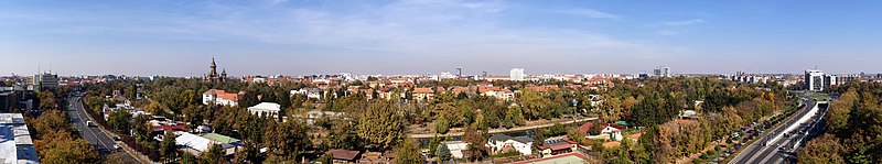
Panoramic view of Timișoara, Romania from the centre towards the North
| Warning | The original file is very high-resolution. It might not load properly or could cause your browser to freeze when opened at full size. |
|---|
Summary
[edit]
| Description |
English: Panoramic view of Timișoara, Romania from the centre towards the North |
| Date | |
| Source | Own work |
| Author | Flavius Ivașca |
| Camera location | | View this and other nearby images on: OpenStreetMap |
|---|
Licensing
[edit]
I, the copyright holder of this work, hereby publish it under the following license:
This file is licensed under the Creative Commons Attribution-Share Alike 4.0 International license.
- You are free:
- to share – to copy, distribute and transmit the work
- to remix – to adapt the work
- Under the following conditions:
- attribution – You must give appropriate credit, provide a link to the license, and indicate if changes were made. You may do so in any reasonable manner, but not in any way that suggests the licensor endorses you or your use.
- share alike – If you remix, transform, or build upon the material, you must distribute your contributions under the same or compatible license as the original.
File history
Click on a date/time to view the file as it appeared at that time.
| Date/Time | Thumbnail | Dimensions | User | Comment | |
|---|---|---|---|---|---|
| current | 20:49, 21 October 2019 | 20,177 × 3,754 (27.36 MB) | Scooter20 (talk | contribs) | User created page with UploadWizard |
You cannot overwrite this file.
File usage on Commons
There are no pages that use this file.
File usage on other wikis
The following other wikis use this file:
- Usage on en.wikipedia.org
- Usage on ro.wikipedia.org