File:RMS Umbria (1884) (51012166713).jpg

Original file (2,592 × 1,944 pixels, file size: 4.71 MB, MIME type: image/jpeg)
Captions
Captions
Summary
[edit]_(51012166713).jpg&action=edit§ion=1)
| Description |
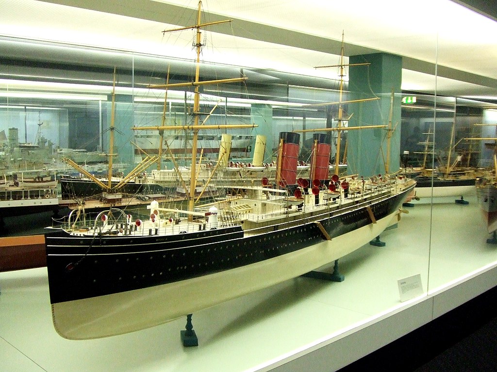
A model of the Trans-Atlantic passenger liner RMS Umbria at the Glasgow Transport Museum, 2 March 2007. The Umbria (and her sister RMS Etruria) was built by John Elder & Co, Govan being launched and completed in 1884 (the Etruria in 1885). She had a 1,559 nhp reciprocating steam engine, a single screw and a barque-rig (the sisters were the last Cunarders to have an auxiliary sailing rig), giving her a maximum speed of 19 kts. She measured 519 ft x 57 ft x 21.4 ft and weighed 7,718 tons gross. She was the second largest ship in the world, second only to the Great Eastern, and her first class accommodation was particularly luxurious. The Umbria was built for the ‘express’ Liverpool – New York service and was noted as being very fast although it was her sister Etruria which first broke the speed record and won the Blue Riband of the Atlantic in 1885. However, Umbria won it in 1887 only for Etruria to win it back in 1888. In 1885 there was the threat of war with Russia following the Pandjeh Incident and the Admiralty commandeered both vessels. The Etruria was soon returned to Cunard but the Umbria was converted into an Armed Merchant Cruiser and was not returned until later in the year. In the Boer War 1899-1902 the Umbria (but not the Etruria) was again used by the Admiralty, carrying troops to South Africa. Back in normal service in 1903, when in New York harbour, the Mafia planted a bomb in the Umbria which was fortunately diffused. The Mafia wanted to destroy British shipping interests in New York. The Umbria was taken out of service in 1910 and scrapped, outliving her sister by a year. |
| Date | |
| Source | RMS Umbria (1884) |
| Author | Hugh Llewelyn from Keynsham, UK |
| Camera location | | View this and other nearby images on: OpenStreetMap |
|---|
_(51012166713).jpg¶ms=055.870988_N_-004.300550_E_globe:Earth_type:camera_source:Flickr_&language=en)
Licensing
[edit]_(51012166713).jpg&action=edit§ion=2)
- You are free:
- to share – to copy, distribute and transmit the work
- to remix – to adapt the work
- Under the following conditions:
- attribution – You must give appropriate credit, provide a link to the license, and indicate if changes were made. You may do so in any reasonable manner, but not in any way that suggests the licensor endorses you or your use.
- share alike – If you remix, transform, or build upon the material, you must distribute your contributions under the same or compatible license as the original.
| This image was originally posted to Flickr by hugh llewelyn at https://flickr.com/photos/58433307@N08/51012166713. It was reviewed on 19 December 2021 by FlickreviewR 2 and was confirmed to be licensed under the terms of the cc-by-sa-2.0. |
File history
Click on a date/time to view the file as it appeared at that time.
| Date/Time | Thumbnail | Dimensions | User | Comment | |
|---|---|---|---|---|---|
| current | 20:11, 19 December 2021 | | 2,592 × 1,944 (4.71 MB) | Siloepic (talk | contribs) | Transferred from Flickr via #flickr2commons |
You cannot overwrite this file.
File usage on Commons
There are no pages that use this file.
_(51012166713).jpg&oldid=666612597)