File:RER B.PNG
Jump to navigation
Jump to search

Size of this preview: 743 × 599 pixels. Other resolutions: 298 × 240 pixels | 595 × 480 pixels | 936 × 755 pixels.
Original file (936 × 755 pixels, file size: 94 KB, MIME type: image/png)
Captions
Captions
Add a one-line explanation of what this file represents
Summary
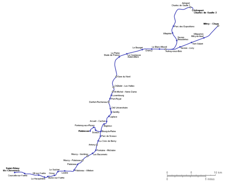
[edit]| Description | Geographically accurate path of the line B of Paris RER (made by Metropolitan). |
| Source | Own work |
| Author | en:User:Metropolitan |
| Other versions |
|


|
This transport map image could be re-created using vector graphics as an SVG file. This has several advantages; see Commons:Media for cleanup for more information. If an SVG form of this image is available, please upload it and afterwards replace this template with
{{vector version available|new image name}}.
It is recommended to name the SVG file “RER B.svg”—then the template Vector version available (or Vva) does not need the new image name parameter. |
Licensing
[edit]
| I, the copyright holder of this work, release this work into the public domain. This applies worldwide. In some countries this may not be legally possible; if so: I grant anyone the right to use this work for any purpose, without any conditions, unless such conditions are required by law. |
File history
Click on a date/time to view the file as it appeared at that time.
| Date/Time | Thumbnail | Dimensions | User | Comment | |
|---|---|---|---|---|---|
| current | 07:28, 11 September 2019 | | 936 × 755 (94 KB) | ديفيد عادل وهبة خليل 2 (talk | contribs) | == {{int:filedesc}} == {{Information |Description= Geographically accurate path of the line B of Paris RER (made by Metropolitan). |Source= {{own}} |Date= |Author= en:User:Metropolitan |Permission= |other_versions= <gallery> RER B.svg|svg RER B.gif|gif </gallery> }} {{Convert to SVG|transport map}} == {{int:license-header}} == {{PD-self}} Category:Maps of Paris RER ligne B |
You cannot overwrite this file.
File usage on Commons
The following 5 pages use this file: