File:RENFE 334 020 Calasparra.jpg
Jump to navigation
Jump to search

Size of this preview: 800 × 494 pixels. Other resolutions: 320 × 198 pixels | 640 × 395 pixels | 1,024 × 632 pixels | 1,280 × 790 pixels | 2,560 × 1,580 pixels | 6,186 × 3,819 pixels.
Original file (6,186 × 3,819 pixels, file size: 5.1 MB, MIME type: image/jpeg)
Captions
Captions
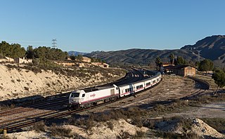
RENFE 334 020 with an IC to Madrid leaves Calasparra
Summary
[edit]
| Description |
Español: La locomotora n.º 334 020 de Renfe a la cabeza del tren Talgo Cartagena-Madrid a su paso por la estación de Calasparra (Murcia, España).
English: RENFE 334 020 with an IC to Madrid leaves Calasparra, Spain
Deutsch: 334 020 der RENFE verlässt Calasparra (Spanien) mit einem IC nach Madrid |
| Date | |
| Source | Own work, also available at https://bahnbilder.ch/picture/25310 |
| Author | Kabelleger / David Gubler |
| Camera location | | View this and other nearby images on: OpenStreetMap |
|---|
Licensing
[edit]
I, the copyright holder of this work, hereby publish it under the following license:
This file is licensed under the Creative Commons Attribution-Share Alike 4.0 International license.
- You are free:
- to share – to copy, distribute and transmit the work
- to remix – to adapt the work
- Under the following conditions:
- attribution – You must give appropriate credit, provide a link to the license, and indicate if changes were made. You may do so in any reasonable manner, but not in any way that suggests the licensor endorses you or your use.
- share alike – If you remix, transform, or build upon the material, you must distribute your contributions under the same or compatible license as the original.
File history
Click on a date/time to view the file as it appeared at that time.
| Date/Time | Thumbnail | Dimensions | User | Comment | |
|---|---|---|---|---|---|
| current | 21:52, 28 February 2022 | | 6,186 × 3,819 (5.1 MB) | Kabelleger (talk | contribs) | Uploaded own work with UploadWizard |
You cannot overwrite this file.
File usage on Commons
The following page uses this file:
File usage on other wikis
The following other wikis use this file:
- Usage on es.wikipedia.org