File:RAI 60-980 Babak - Khorasanak.jpg
Jump to navigation
Jump to search

Size of this preview: 800 × 494 pixels. Other resolutions: 320 × 198 pixels | 640 × 395 pixels | 1,024 × 632 pixels | 1,280 × 790 pixels | 2,560 × 1,580 pixels | 5,956 × 3,677 pixels.
Original file (5,956 × 3,677 pixels, file size: 9.24 MB, MIME type: image/jpeg)
Captions
Captions
Add a one-line explanation of what this file represents
Summary
[edit]
| Description |
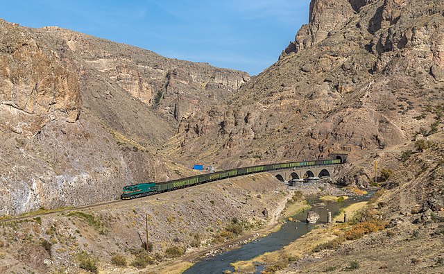
English: Islamic Republic of Iran Railways's 60-980 (an EMD GT26CW-2) hauls a freight train through the Gharanghu river canyon, between Meyaneh and Maragha, Iran. Digital manipulations: Removed shadow of a mountain.
Deutsch: 60-980 (eine EMD GT26CW-2) der Islamic Republic of Iran Railways zieht einen Güterzug durch die Schlucht des Flusses Gharanghu zwischen Miyaneh und Maragha, Iran. Digitale Manipulationen: Schatten eines Berges entfernt. |
| Date | Taken on 24 October 2017, 14:08:46 |
| Source | Own work, also available at https://bahnbilder.ch/picture/28483 |
| Author | Kabelleger / David Gubler |
| Camera location | | View this and other nearby images on: OpenStreetMap |
|---|
Licensing
[edit]
I, the copyright holder of this work, hereby publish it under the following license:
This file is licensed under the Creative Commons Attribution-Share Alike 4.0 International license.
- You are free:
- to share – to copy, distribute and transmit the work
- to remix – to adapt the work
- Under the following conditions:
- attribution – You must give appropriate credit, provide a link to the license, and indicate if changes were made. You may do so in any reasonable manner, but not in any way that suggests the licensor endorses you or your use.
- share alike – If you remix, transform, or build upon the material, you must distribute your contributions under the same or compatible license as the original.
Assessment
[edit]
|
This image has been assessed using the Quality image guidelines and is considered a Quality image.
|
File history
Click on a date/time to view the file as it appeared at that time.
| Date/Time | Thumbnail | Dimensions | User | Comment | |
|---|---|---|---|---|---|
| current | 13:47, 4 November 2017 | | 5,956 × 3,677 (9.24 MB) | Kabelleger (talk | contribs) | User created page with UploadWizard |
You cannot overwrite this file.
File usage on Commons
The following 3 pages use this file:
File usage on other wikis
The following other wikis use this file:
- Usage on ceb.wikipedia.org
- Usage on en.wikipedia.org
- Usage on fa.wikipedia.org
- Usage on www.wikidata.org
Metadata
Categories:
- 2017 in rail transport in Iran
- RAI EMD GT26
- Qaranqu River
- Bridges over the Qaranqu River
- Tehran–Tabriz Railway
- Rail transport in East Azerbaijan Province
- Tunnels in East Azerbaijan Province
- Mountains of East Azerbaijan Province
- Hashtrud County
- Rail tunnels in Iran
- Trains on bridges in Iran
- Trains in tunnels in Iran
- Trains nearby rivers