File:R33 by Assegaairivier, Piet Retief, Mpumalanga, a.jpg
Jump to navigation
Jump to search

Size of this preview: 800 × 430 pixels. Other resolutions: 320 × 172 pixels | 640 × 344 pixels | 1,024 × 550 pixels | 1,280 × 688 pixels | 2,560 × 1,375 pixels | 4,439 × 2,385 pixels.
Original file (4,439 × 2,385 pixels, file size: 2.37 MB, MIME type: image/jpeg)
Captions
Captions
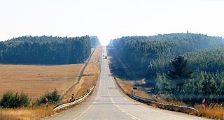
R33 route in eastern Mpumalanga, South Africa
Summary
[edit]
| Description |
Afrikaans: Die vallei van die Assegaairivier word suid van Piet Retief deur die R33-roete oorgesteek
English: R33 route at Assegaai River, just south of Piet Retief, Mpumalanga |
| Date | |
| Source | Own work |
| Author | JMK |
| Camera location | | View this and other nearby images on: OpenStreetMap |
|---|
Licensing
[edit]
I, the copyright holder of this work, hereby publish it under the following license:
This file is licensed under the Creative Commons Attribution-Share Alike 4.0 International license.
- You are free:
- to share – to copy, distribute and transmit the work
- to remix – to adapt the work
- Under the following conditions:
- attribution – You must give appropriate credit, provide a link to the license, and indicate if changes were made. You may do so in any reasonable manner, but not in any way that suggests the licensor endorses you or your use.
- share alike – If you remix, transform, or build upon the material, you must distribute your contributions under the same or compatible license as the original.
File history
Click on a date/time to view the file as it appeared at that time.
| Date/Time | Thumbnail | Dimensions | User | Comment | |
|---|---|---|---|---|---|
| current | 22:15, 27 June 2019 | | 4,439 × 2,385 (2.37 MB) | JMK (talk | contribs) | {{Information |description ={{en|1=R33 route at Assegaai River, just south of Piet Retief, Mpumalanga}} |date =2019-06-17 |source ={{own}} |author =JMK }} Category:R33 road (South Africa) Category:Piet Retief, Mpumalanga |
You cannot overwrite this file.
File usage on Commons
The following 2 pages use this file:
File usage on other wikis
The following other wikis use this file:
- Usage on af.wikipedia.org
- Usage on en.wikipedia.org
- Usage on www.wikidata.org