File:Réservoirs de biodiversité et réseau hydrographique de Loire-Atlantique.svg
Jump to navigation
Jump to search

Size of this PNG preview of this SVG file: 800 × 565 pixels. Other resolutions: 320 × 226 pixels | 640 × 452 pixels | 1,024 × 723 pixels | 1,280 × 904 pixels | 2,560 × 1,808 pixels | 1,123 × 793 pixels.
Original file (SVG file, nominally 1,123 × 793 pixels, file size: 7.66 MB)
Captions
Captions
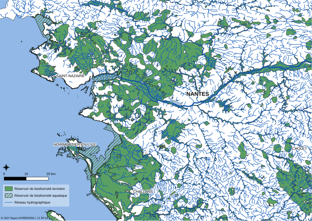
Map of biodiversity reservoirs and the hydrographic grid of the Loire-Atlantique department (44) in France
Summary
[edit]
| Description |
Français : Carte représentant les réservoirs de biodiversité et le réseau hydrographique du département de Loire-Atlantique (44) en France.
Réalisé avec QGIS le 25/11/2020. Les données utilisées sont disponibles aux liens suivants : Réservoirs de biodiversité : https://www.data.gouv.fr/fr/datasets/srce-reservoirs-de-biodiversite-des-trames-verte-et-bleue-en-pays-de-la-loire/ Réseau hydrographique : https://www.data.gouv.fr/fr/datasets/reseau-hydrographique-metropole/ |
| Date | |
| Source | Own work |
| Author | Rayan Khireddine |
| Camera location | | View this and other nearby images on: OpenStreetMap |
|---|
Licensing
[edit]
I, the copyright holder of this work, hereby publish it under the following license:
This file is licensed under the Creative Commons Attribution-Share Alike 4.0 International license.
- You are free:
- to share – to copy, distribute and transmit the work
- to remix – to adapt the work
- Under the following conditions:
- attribution – You must give appropriate credit, provide a link to the license, and indicate if changes were made. You may do so in any reasonable manner, but not in any way that suggests the licensor endorses you or your use.
- share alike – If you remix, transform, or build upon the material, you must distribute your contributions under the same or compatible license as the original.
File history
Click on a date/time to view the file as it appeared at that time.
| Date/Time | Thumbnail | Dimensions | User | Comment | |
|---|---|---|---|---|---|
| current | 13:01, 25 January 2021 | | 1,123 × 793 (7.66 MB) | Sieger 14 (talk | contribs) | Modification de la sémiologie de "Réservoirs de biodiversité aquatique" |
| 12:49, 25 January 2021 |  | 1,052 × 744 (6.95 MB) | Sieger 14 (talk | contribs) | Modification de la sémiologie de "Réservoirs de biodiversité aquatiques" | |
| 16:47, 16 January 2021 |  | 1,052 × 744 (6.84 MB) | Sieger 14 (talk | contribs) | Correction du décalage de texte de la légende du au format svg | |
| 13:43, 13 January 2021 |  | 1,123 × 793 (7.95 MB) | Sieger 14 (talk | contribs) | - amélioration de la sémiologie : * réservoirs scindés en deux types : réservoirs terrestres et aquatiques, afin de mieux distinguer les trait de côte * augmentation générale de la police de caractère des toponymes, légende et crédits - ajout de toponymes supplémentaires | |
| 19:15, 25 November 2020 |  | 1,123 × 793 (6.36 MB) | Sieger 14 (talk | contribs) | Uploaded own work with UploadWizard |
You cannot overwrite this file.
File usage on Commons
The following page uses this file:
- File:Carte teste page sieger14.svg (file redirect)
File usage on other wikis
The following other wikis use this file:
- Usage on fr.wikipedia.org