File:Réserve naturelle régionale de la carrière des Nerviens map-fr.svg
Jump to navigation
Jump to search

Size of this PNG preview of this SVG file: 671 × 495 pixels. Other resolutions: 320 × 236 pixels | 640 × 472 pixels | 1,024 × 755 pixels | 1,280 × 944 pixels | 2,560 × 1,889 pixels.
Original file (SVG file, nominally 671 × 495 pixels, file size: 1.94 MB)
Captions
Captions
Add a one-line explanation of what this file represents
Summary
[edit]
| Camera location | | View this and other nearby images on: OpenStreetMap |
|---|
| Description |
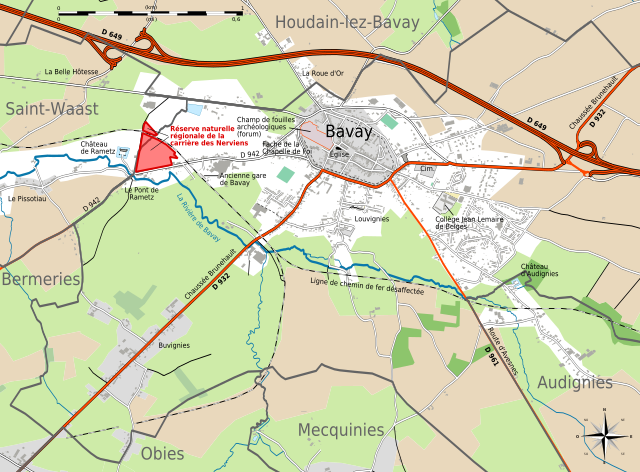
Français : Carte en français de Bavay et de la Réserve naturelle régionale de la carrière des Nerviens (cette dernière localisée en rouge).
Deutsch: Karte der Bavay, in Französische.
English: Map in French language of Bavay.
Español: Mapa en francès de Bavay.
Italiano: Mappa di Bavay (en francese).
日本語: フランス語で表示したBavayの地図.
Português: Carta do Bavay em francês.
|
||
| Date | (UTC) | ||
| Source |
Création personnelle ; données de la carte © les contributeurs d'OpenStreetMap, CC-BY-SA Openstreetmap via Cloudmade ;
|
||
| Author | © Bourrichon (talk) - fr:Bourrichon | ||
| Permission (Reusing this file) |
|

|
This SVG file contains embedded text that can be translated into your language, using any capable SVG editor, text editor or the SVG Translate tool. For more information see: About translating SVG files. |
This W3C-unspecified vector image was created with Inkscape .
Licensing
[edit]
I, the copyright holder of this work, hereby publish it under the following licenses:

|
Permission is granted to copy, distribute and/or modify this document under the terms of the GNU Free Documentation License, Version 1.2 or any later version published by the Free Software Foundation; with no Invariant Sections, no Front-Cover Texts, and no Back-Cover Texts. A copy of the license is included in the section entitled GNU Free Documentation License. |
This file is licensed under the Creative Commons Attribution-Share Alike 3.0 Unported, 2.5 Generic, 2.0 Generic and 1.0 Generic license.
- You are free:
- to share – to copy, distribute and transmit the work
- to remix – to adapt the work
- Under the following conditions:
- attribution – You must give appropriate credit, provide a link to the license, and indicate if changes were made. You may do so in any reasonable manner, but not in any way that suggests the licensor endorses you or your use.
- share alike – If you remix, transform, or build upon the material, you must distribute your contributions under the same or compatible license as the original.
You may select the license of your choice.
File history
Click on a date/time to view the file as it appeared at that time.
| Date/Time | Thumbnail | Dimensions | User | Comment | |
|---|---|---|---|---|---|
| current | 20:56, 9 June 2013 | | 671 × 495 (1.94 MB) | Bourrichon (talk | contribs) | == {{int:filedesc}} == {{Location|50|17|54|N|03|46|35|E|scale:500000}} {{Information |Description= {{fr|Carte en français de Bavay et de la [[:fr:Réserve naturelle régionale de la carrière des Nerviens|Réserve naturelle régionale de... |
You cannot overwrite this file.
File usage on Commons
The following page uses this file:
File usage on other wikis
The following other wikis use this file:
- Usage on de.wikivoyage.org
- Usage on en.wikipedia.org
- Usage on fr.wikipedia.org
- Usage on fr.wikivoyage.org