File:Réseau des Sablières de Nemour superimposed onto OpenStreetMap.jpg
Jump to navigation
Jump to search

Size of this preview: 800 × 488 pixels. Other resolutions: 320 × 195 pixels | 640 × 391 pixels | 1,024 × 625 pixels | 1,280 × 781 pixels | 1,766 × 1,078 pixels.
Original file (1,766 × 1,078 pixels, file size: 631 KB, MIME type: image/jpeg)
Captions
Captions
Add a one-line explanation of what this file represents
Summary
[edit]
| Description |
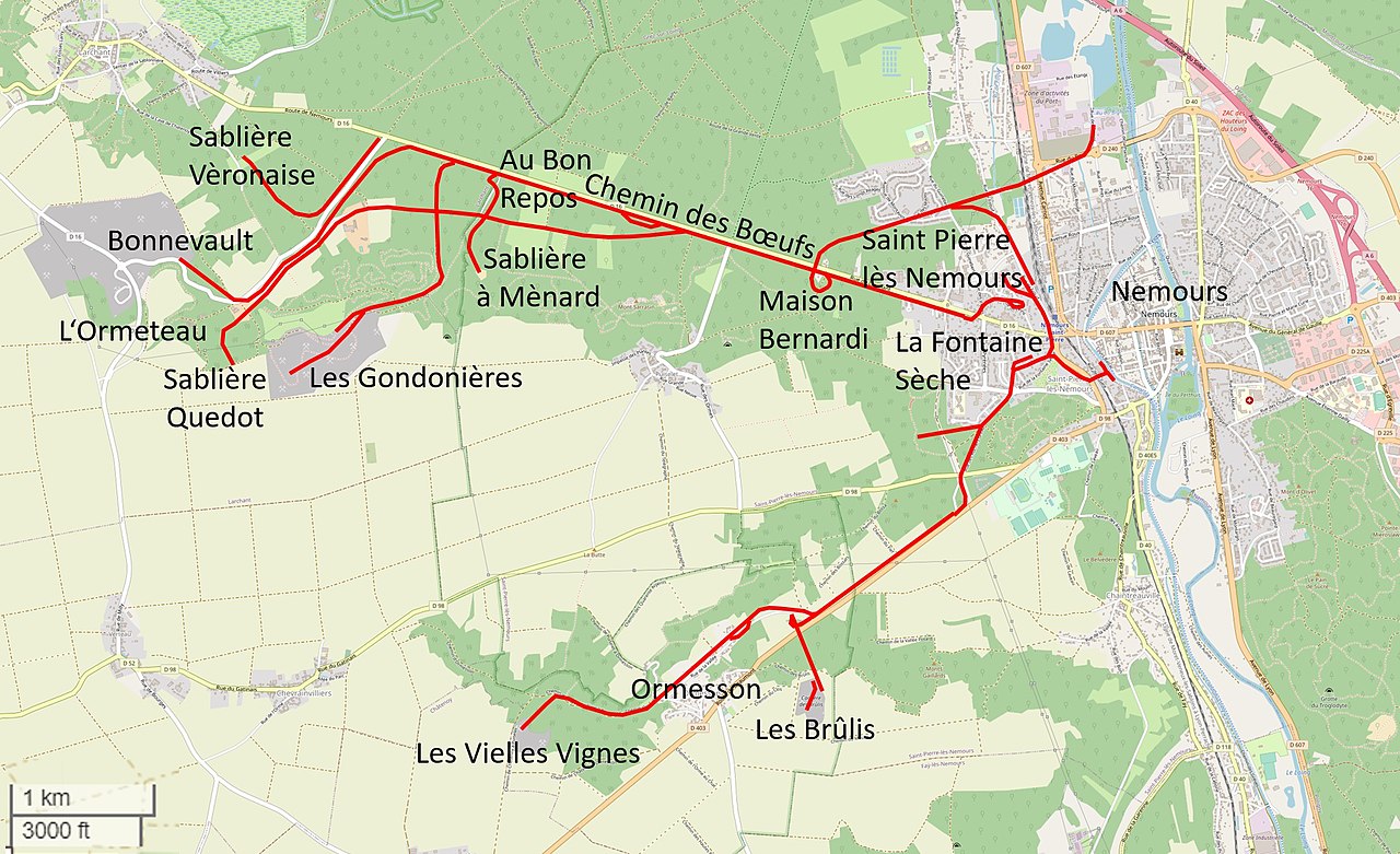
English: Réseau des Sablières de Nemour superimposed onto OpenStreetMap:
|
| Date | |
| Source |
|
| Author |
|
Licensing
[edit]
This file is licensed under the Creative Commons Attribution-Share Alike 2.5 Generic license.
- You are free:
- to share – to copy, distribute and transmit the work
- to remix – to adapt the work
- Under the following conditions:
- attribution – You must give appropriate credit, provide a link to the license, and indicate if changes were made. You may do so in any reasonable manner, but not in any way that suggests the licensor endorses you or your use.
- share alike – If you remix, transform, or build upon the material, you must distribute your contributions under the same or compatible license as the original.
File history
Click on a date/time to view the file as it appeared at that time.
| Date/Time | Thumbnail | Dimensions | User | Comment | |
|---|---|---|---|---|---|
| current | 21:31, 17 May 2022 | | 1,766 × 1,078 (631 KB) | NearEMPTiness (talk | contribs) | Version 1.05 |
| 18:37, 15 May 2022 |  | 1,760 × 1,076 (627 KB) | NearEMPTiness (talk | contribs) | Chemin des Bœufs | |
| 18:27, 15 May 2022 |  | 1,764 × 1,076 (629 KB) | NearEMPTiness (talk | contribs) | Nemours | |
| 14:56, 15 May 2022 |  | 1,760 × 1,078 (627 KB) | NearEMPTiness (talk | contribs) | Ergänzungen nach "Plan général de voies ferrées" | |
| 11:52, 15 May 2022 |  | 1,764 × 1,076 (646 KB) | NearEMPTiness (talk | contribs) | Uploaded a work by *OpenStreetMap-Mitwirkende *Jean Chaintreau *Tacot des Lac *NearEMPTiness from * https://www.openstreetmap.org/#map=14/48.2631/2.6521 *Jean Chaintreau: ''Fontainbleau-Nemours. Des Chemins de Fer des Sablieres au Tacot de Lacs. 150 ans d'histoire.'' Editions Ammateis, 1989. * [http://tacotdeslacs.free.fr/journal/pdf/t28.pdf ''Les sablières de Nemours Part 1.''] Tortillard N° 28 - Site officiel du Tacot des lac. *[http://tacotdeslacs.free.fr/journal/pdf... |
You cannot overwrite this file.
File usage on Commons
The following 2 pages use this file:
File usage on other wikis
The following other wikis use this file:
- Usage on de.wikipedia.org
- Usage on en.wikipedia.org